| Longer than 2 miles | Signed | Active | July 1, 2003 |
| No. | Year(s) | Old/Co. | Length | Proof of life | Other notes |
| 903 | 2011 (but bypassed in 1999) | IA 163 Mahaska |
0.132 (~700 ft.) |
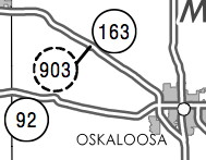 2013 2013 2015 2015 |
This makes absolutely no sense at all. |
| 904 | 2008 (-2009) -2011 |
US
34 Jefferson |
7.8 (4.7) |
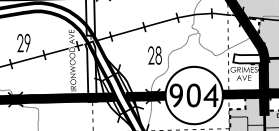 2011 Jefferson (either side of Fairfield city limits). Assigned to old 34 while the state fixed it up, turned city segment over first, then county. |
Only 90x ever issued (until whatever that is, above) |
| 912 | 1997-1999 |
IA 141 Dallas |
0.22 (1161 ft., ca. 387 yds.) | Jason Hancock's research: "near IA 210". Curve just east of 210 had radius significantly increased with four-laning; this might have been old road | Lowest 9xx until 2008 |
| 913 | 1996-1997 |
US 61 Des Moines |
1.7 | Jason Hancock's research: "south of Burlington". Most likely where 61 turns from running NE to N at X62. | |
| 914 | 1996-2003 |
US 71 Buena Vista |
1.01 | 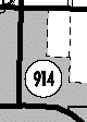
|
Old US 71 north of IA 7 (Bus. 71) in Storm Lake limits |
| 915 | 1986-1990 |
IA 3 and Fayette |
0.3 | Frederick Avenue from new IA 150 south to Charles Street, then east on Charles Street to new 3/150 (approx. 3 blocks) | From two different routes |
| 915 | 1993-1994 |
IA 415 Polk |
3.7 | Jason
Hancock's research: "Both ends are at IA 415 in the Ankeny area,
has
bridge over Rock Creek. My guess is that this was Polk City Drive
west
of Ankeny, as this was once an alignment of 415." Two segments: Polk City Drive and NW Lake Drive |
|
| 915 | 1995-1997 |
IA 5 Monroe |
0.4 | Short realignment between US 34 and downtown Albia across railroad tracks (Clinton Street and 5th Avenue) | |
| 916 | 1986 (-1988) -2003 |
IA 150 Fayette |
2.6 (1986) 1.3 (2003) |
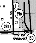 
 2001 2001 |
Makes thicker red line on map; first was from old int. of 3/150 to present S end (IA 3 segment became 915) |
| 917 | 1986-2003 |
IA 22 Muscatine |
0.15 (792 ft., ca. 264 yds.) |
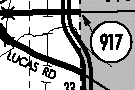 
 2001 2001 |
Result of US 61 Muscatine bypass and reroute of 22 onto it |
| 918 | 1984-2003 |
IA 16 Wapello |
1.12 | 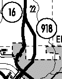

|
Makes thicker black line on map; "Hwy 918" sign on road |
| 919 | 1984-1995 |
IA 363 Benton |
0.3 | Jason Hancock's research: Old part into Urbana removed when 363 was rerouted north of town to I-380 | State-Ash- Wood, end at Walnut |
| 920 | 1984-2003 |
IA 150 Benton/ Linn |
12.56 | 
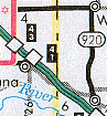 2001 2001 |
Old 150 that did not parallel I-380 |
| 921 | 1983-1984 |
IA 150 Linn |
1.1 | 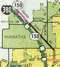
1983 Cedar Rapids (921 in Hiawatha only) |
Center Pt./ Boyson Rd. to NCL CR |
| 921 | 1984-1985 |
IA 150 Linn |
12.5 | Jason Hancock's research: All of old 150 between SCL Center Point and NCL Cedar Rapids (extension of above 921), paralleled I-380 | Now W6E |
| 921 | 1985-2003 |
US 218 Johnson |
2.49 |   |
Old 218 segment south of US 6 designated at same time as 965; there were two "Hwy 921" signs on road |
| 922 | 1984-1986 |
US 61 Muscatine |
1.3 | Jason Hancock's research: Old 61 btwn. bypass and IA 22; now IA 38/22 | Park Avenue in Muscatine |
| 922 | 1987-1988 |
IA 149 Iowa |
1.3 | Jason Hancock's research: "through North English". Realigned curve at county line | |
| 922 | July 7, 1989 |
US 151 Linn |
8.82 | 
 2001 2001 |
Business US 151 in Cedar Rapids |
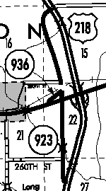
| 923 | 1982, 1983, 1985, (-1991), 1997 - 2003 |
US 218 Johnson/ Washington |
4.5 (1982) 9.0 (1983) 21.3 (1985) 19.5 (1991) 26.49 (1/1/03) |
FAR LEFT: Middle part, see big map; LEFT: 1986 1982-83: Hills to IA 22 1983-85: Iowa City (Riverside Dr., current N end) to Hills 1985-91: Iowa City to Ainsworth (in '91, 2 mi. S of G36 decom'd) 1997-2003: Broken - Ainsworth and Crawfordsville segments added |
Old US 218 designated in segments as freeway was completed Segment at left is east of Ainsworth See below map for more info Wash. Co. turned over April 1, 2003; rest July 1 |
| 924 | 1980-1982 |
None (P29) Webster |
4 | 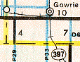 1981 (924 is by "4", 144 by
"7")
1981 (924 is by "4", 144 by
"7") |
Not any road before or since; IA 144 nearby was decom'd, restored |
| 924 | 1982-1993 |
US 61/151 Dubuque |
2.2 | 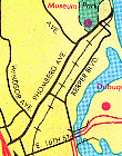 1991 Dubuque
 |
Rhomberg Avenue to old Eagle Point bridge |
| 924 | 1994-2003 |
US 61/ Lee |
0.67 | ;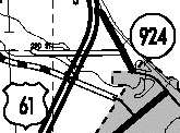
 |
Was 998 before 1994; see big map below |
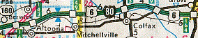
| 925 | 1980-2003 |
US 6 Adair/ Guthrie/ Dallas |
26.11 | 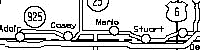 Below:
2001 Below:
2001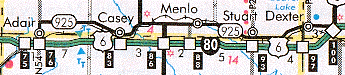 |
Since reroute of 6 in 1980 with first 926 and 927 |
| 926 | 1980 -1981 -1988 |
US 6 Polk/ Jasper |
6.6 (1980) 3.2 (1981) |
 Only
926 in
Altoona and east of 117 to I-80 (1981 map) Only
926 in
Altoona and east of 117 to I-80 (1981 map) |
Segment not all 926, but marked as such here; now F48 |
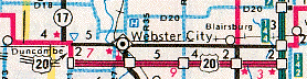
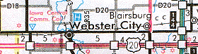
| 926 | 1990-2014 |
IA 7 and US 20 Webster |
3.17 |   2001 2001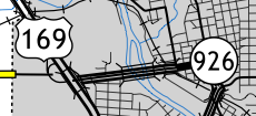 2015 2015 |
E'most part of IA 7, plus part of old 20; now Business 169 |
| 927 | 1980-2003 |
US 6 Muscatine/ Cedar/Scott |
19.02 | Signs up in 1989 | |
| 928 | 1980,
1987 (-1988) -2003 |
US 20 (Webster/) Hamilton |
17.2 (1980) 30.6 (1987) 20.58 (2003) |
|
Not in Webster City; signs on I-35; incl. part through Williams; W end at IA 17 ('80), Ft. Dodge ('87), then county line ('88-'03) |
| 929 | 1980-2003 |
IA 152 Clarke |
0.79 | 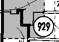 
 2001
DeLorme 2001
DeLorme |
1 of 3 from decom'd state routes; in wrong spot on DeLorme |
| 930 | 1976
(-1980) (-1989) |
US 30 Boone (/Story) (/Marshall) |
48 (1976) 12.9 (1980) 2.3 (1989) 1.79 (2002) |
* Jason's research says segment in Ames decom'd in '80, only part in Story Co. was btwn. line and WCL Ames; 0.5 mi. (WCL to line) gone in '89
|
Previously
designated Alt 30 Story Co. decom'd in '80, maybe in 2 parts; Marshall decom'd in '89; only in Boone Co. (W of R38) |
| 931 | 1976-1978 | IA 13 Linn |
1.2 | Old IA 13 in Coggon (3rd and Linn streets) | |
| 931 | 1980-2003 |
none (F32) Polk |
8.96 | 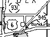 Below:
2002 Below:
2002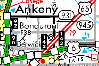 |
931 and 945 came from nowhere, not part of any old road Unsigned in 2001; see 945 Turned over to Polk Co. in other contract |
| 932 | 1976-2003 |
IA 13 Delaware |
0.19 (1003 ft., ca. 334 yds.) |
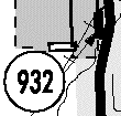
|
|
| 933 | 1977-1984 |
IA 141 Dallas |
0.7 | From 141 bypass | |
| 933 | 1985 (-1994) -1999 |
IA 58 Black Hawk |
.57 (1985) .21 (1994) |
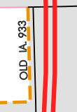 2015 Hudson 2015 Hudson |
Iowa Traveler's Atlas, 1993: Waterloo map shows that old piece of IA 58 near southwest corner of US 20/IA 58 interchange had this number |
| 934 | 1976-1980 |
US 61 Des Moines |
1.1 |  1977
Burlington 1977
Burlington |
|
| 934 | 1981-1989 |
IA 90 Polk |
1.1 | Jason Hancock's research: "Dallas/Polk county line to I-35" (Grand Avenue) | Now in WDM limits |
| 934 | 1990-1991 |
US 20 Webster |
4.8 |  1991 1991 |
W part of current Bus. 20 |
| 934 | 1992-1994 |
US 34 Lucas |
0.19 (1003 ft., ca. 334 yds.) |
Jason
Hancock's research: "It was a short stub of old 34 east of the IA
97
intersection." Now frontage road in front of Russell Sale Barn. |
|
| 934 | 1998 (-2015) -2016 |
none at time (was US 218) Black Hawk |
4.82 |   2001 2001 |
University Avenue btwn. 58 and 63/218 after 58 extension |
| 935 | 1976-1981 |
US 34 Des Moines |
0.77 | Jason Hancock's research: "US 34 to West Burlington WCL, probably the old segment of US 34 extending eastward from the west end of the freeway." (Freeway was constructed 1974-76) | |
| 935 | 1982-2003 |
IA 370 Mills |
1.49 | 
 2001 2001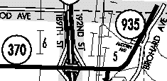 |
Mills Co. only; old 370 in Pott. H10 on PDF map (and now signed as such) |
| 936 | 1976-1995 |
IA 406 Des Moines |
0.09 (475 ft., ca. 158 yds.) | ECL West
Burlington to WCL Burlington In Sec. 36 of plat, but no sign of old road anywhere |
|
| 936 | 1997-2003 |
IA 92? Washington |
0.27 |
See 923 entry on p. 1 for more context. |
Purpose of segment unknown; turned over on April 1 |
| 937 | 1976-1980 |
IA 2 Davis |
5.8 | 1976 traffic book via Alex Latham's
research |
|
| 937 | 1977-2003 |
IA 141 Dallas |
0.46 | 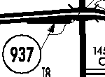
|
Just to the west of the US 169 interchange |
| 938 | 1975-1980 |
IA 116 Delaware |
1.6 | Jason Hancock's research: "US 20 to fish hatchery in Delaware County" | 116 itself used for secret # in 1990s |
| 938 | 1980-2003 |
IA 369 Appanoose |
0.46 | 
|
T61 in U'ville; old part of spur |
| 939 | 1972-1980 |
IA 2 Wayne |
6.7 |  1974 1974 |
|
| 939 |
1980, |
US 20 Buchanan (/Black Hawk) |
12.4 (1980) 29.2 (1983) 18.94 (2003) |
 1981 1981 |
Orig. from 150 to 187; extended to 297 in '83, but only segment in Raymond remained |
| 940 | 1960s-1980 |
IA 2 Appanoose |
2.51 | Segments of IA 2 left behind at IA 142, Sunshine, and the west side of Centerville | |
| 940 |
1980-2003 |
IA 212 Benton |
0.08 (422 ft., ca. 140 yds.!) |
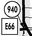
|
Signed as E66, even in Benton Co.; enter Tama Co. almost as soon as you turn |


 2015
2015 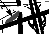 In
gray;
compare to the 218/92 interchange ramps. Vertical black line is
IA 923 (old 218).
In
gray;
compare to the 218/92 interchange ramps. Vertical black line is
IA 923 (old 218).