| Longer than 2 miles | Signed | Active | July 1, 2003 |
| No. | Year(s) | Old/Co. | Length | Proof of life | Other notes |
| 102 | Became secret route May 1, 2003 | Mahaska | 0.5 | 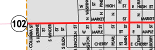
2011 New Sharon |
Not turned over inside New Sharon in 2003, apparently |
| 107 | June 4, 2003 (-2010) -2011 |
Cerro Gordo | 2.5 | 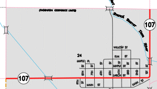 2011 Thornton |
Not turned over in 2003; Meservey, Thornton received their segments on two dates |
| 116 | Dec. 2, 1998 |
US 218 Bremer |
2.62 | 
 2001
(big map below) 2001
(big map below) |
Bus. 218 S of IA 3; see big map below |
| 162 | 2000 (-2001) -2006 (segment is now part of US 18) |
US 218 Floyd |
4.18 |
|
Bus. 218 S of US 18; see big map below |
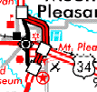
| 231 | 2000-2003 | US 34 Henry |
4 |  LEFT:
2002; BELOW: 2003 LEFT:
2002; BELOW: 2003 |
|
| 254 | 2003-2004 | US 218 Floyd/ Chickasaw |
2.6 | Old US 218 in Nashua (after 1960ish) | |
| 263 | 2000-2003 | US 20 Grundy (/Black Hawk) |
12.3 | 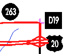  2001
2001 |
|
| 289 | 2000-2003 | US 61 Muscatine |
2.27 |
Bypassed segment farther south was closer to river |
|
| 296 | 2000 (-2001) (-2003) -2011 |
IA 28 Polk/ Warren |
0.29 | 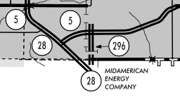 2010 2010 |
SW 42nd St |
| 303 | 2004 | US 151 Jones |
4.1 | Old 151 through Monticello excluding IA 38 section | Noted on document from Wis. DOT |
| 312 | 2002-2003 | US 65 Polk/Jasper |
? |  2003
(both) 2003
(both) 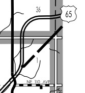 |
"Marsh Kink" at Jasper County line; part has since been removed |
| 331 | 2002-2005 | IA 5 Polk |
3.8 | 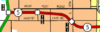 2003 Des Moines inset 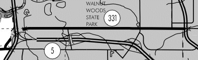 2003 |
Army Post Road in West Des Moines |
| 334 | 2006-2007 | US 34 Wapello |
0.8+5.5 |  2003 2003 |
2 parts: Roemer Avenue and through Agency |
| 335 | 1999-2001 |
IA 163 Marion |
1.1 | 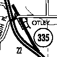  |
|
| 337 | 2000-2001 | US 218 Floyd |
2.7 | SEE BOTTOM | North segment of present Bus. 218 |
| 337 | 2003-2004 | US 151 Jones |
1 |  2004 2004 |
First reused non-900 secret # |
| 340 | 2005-2007 | US 34 Jefferson |
1.2 | From creation of bypass through Batavia | First reused number from route killed in 2003 |
| 341 | 1988 or 1993-2003 |
IA 341 Palo Alto |
0.06 (317 ft., ca. 105 yds.) |
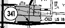 2003 2003 |
Remnant of original 341 to Lost Island Lake State Park |
| 342 | 2004-2005 | US 63 Wapello/ Mahaska |
Either 1 or 2.2 | 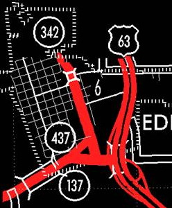 2003
DOT archives
2003
DOT archives |
Old 63 through Eddyville |
| 356 | 2000-2003 | US 71 Dickinson |
0.94 |  2001 2001  2002
2002  |
Smudge on 2001 map |
| 368 | 2002 (-2004) |
IA 5 Warren |
0.1 | 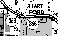 Segment at upper left of 2003 map still active, apparently  2011
aerial photo (NW-SE two-lane) 2011
aerial photo (NW-SE two-lane) |
KCCI had shield indicator for this on map in 2010. Probably the silliest remaining segment. Or second- silliest, after we figure out what IA 903 is. |
| 373 | 2002-2003 |
US 61/ Muscatine |
0.7 | 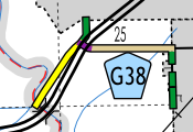 2015 (in yellow)
Two segments between Muscatine/Louisa line and Business 61 |
Turned over May 1 and June 6, 2003 |
| 374 | 1999-2000 |
IA 163 Jasper |
1.5 | 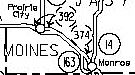 |
East dead-end stub serves PCM school |
| 376 | Nov. 19, 2001 |
US 75 Woodbury |
9 |  2015
2015 |
Former (now Business) US 75 through Sioux City; thanks to Kurt Berge for finding it |
| 377 | 1980-2003 |
IA 377 Woodbury |
0.21 (1108 ft., ca. 369 yds.) |
  2001
Sioux City
2001
Sioux City |
Part of original 377 in SC; rest turned over in 1980 |
| 390 | 2002-2003 |
US 218 Bremer |
2.1 |
|
|
| 392 | 1998-2000 |
IA 163 Jasper |
3.5 | 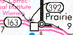 2000 2000 |
|
| 404 | 2004 -2005, 2006 (-2007) |
IA
60/ US 75 Plymouth |
Various 1.6 (2008) |
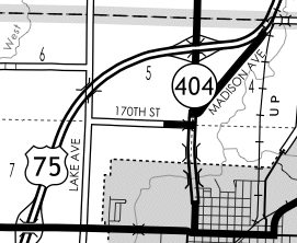 2011
2011 |
Assigned to each bypassed segment of IA 60 as four-lane was built, then turned over. Old US 75 segment north of Le Mars will stay |
| 421 | 2000-2003 |
US 61 Muscatine, Scott |
0.71 | 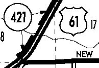 2001
2001 Also assigned to old 61 through Blue Grass |
Right along old 61 NE of Muscatine; Jason Hancock says trailer park and Casey's on road |
| 424 | 1999-2003 |
US 218 Henry |
2.81 |   2001
(See big map below)
2001
(See big map below) |
See big map below; old 218 N and S of IA 78 |
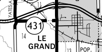
| 431 | 1998-2001 |
US 218 Bremer |
1.89 | See 116 map (segment outside of Waverly) | Bus. 218 N of IA 3; see big map below |
| 431 | 2004 (-2005) -2011? |
US
30 Marshall |
1.6 (0.6) |
 2010
2010 |
Apparently lasted longer in rural Marshall County |
| 432 | 1997-2002 |
IA 163 Mahaska |
1.9 | 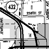  2000
2000 |
BGSs at S end stayed from when it was 163 until late 2003 or early 2004 |
| 434 | 2005 (-2007) -2008 |
US 34 Des Moines |
6.7 | 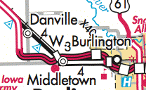 2006 2006 |
Part through Danville lasted one winter longer |
| 437 | 2005-2009 | IA 137 Wapello |
0.3 | Eddyville change; road now abandoned - SEE 342 MAP ABOVE | On city maps thru decade |
| 438 | 2001 (-2004) (-2005) |
US
218 Henry |
?
(2001) 0.5-ish (2011) |
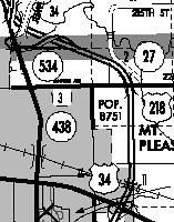
 2003 2003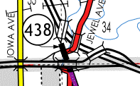 2011
2011 |
Only from eastbound US 34 ramps north to mainline US 218 (see the purple at bottom of 2011 map? That's old 218 but not 438) |
| 450 | 2005 | None (connector between IA 10 and IA 60) Sioux |
0.3 | 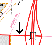 2011 Alton
 |
Named for 450th Street in Sioux County |
| 460 | 2004-2007 | IA 27 Lee |
5.5 |  2006 2006 |
Assigned to all bypassed segments of IA 394 |
| 461 | 2011 | US
61 Scott |
11 | 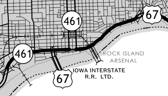 2011
2011 |
Business US 61 from I-280 to I-80 |
| 463 | 2009-2011 | US 63 Chickasaw |
2.2 | Northwest of Frederika, bypassed by four-lane diagonal | |
| 470 | 2011??? | US 75 Plymouth |
0.7 | 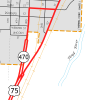 2016
Merrill 2016
Merrill |
This was bypassed in 1958; no idea when it was added to state system; no evidence before 2010s |
| 475 | 1969-1975 |
US 75 Woodbury/ Monona |
31.8 |  1973 Rand McNally (prob. not signed in Iowa)
 |
Renamed IA 970 in 1975; old 75 N of Onawa; see also 970 |
| 478 | 2002-2003 | US 63 Chickasaw |
0.7 | Segment in New Hampton | |
| 520 | 1968-1976 |
new road (to be 20) Hamilton |
3 |  1973 Rand McNally (prob. not signed in Iowa) |
Oldest freeway part; also 520 in Sioux City |
| 534 | Multiple | new road (to be 34) Henry (/Mills?) |
N/A | SEE 438 map above. Was connection between 218 bypass and old 218 until freeway was completed. Number may have been applied to new segment in Mills County before rerouting. |
 2001
(does NOT touch 218;
big map below)
2001
(does NOT touch 218;
big map below)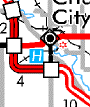 2002;
notice that
alongside 218 it is gray (turned over), but a gray portion north
of 218
(T64) is now black. Swapped most of 162 for this part of T64
(also see
big map below to show it was T64)
2002;
notice that
alongside 218 it is gray (turned over), but a gray portion north
of 218
(T64) is now black. Swapped most of 162 for this part of T64
(also see
big map below to show it was T64)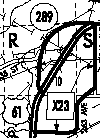 (north part;
2 parts; see below)
(north part;
2 parts; see below)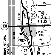
 2003 (both)
 Large maps
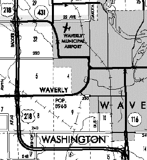
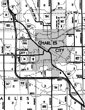
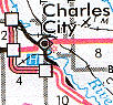
Old 218 as IA 116 and 431 in Waverly / Old IA 162 and 337 in Charles City (2000 maps)
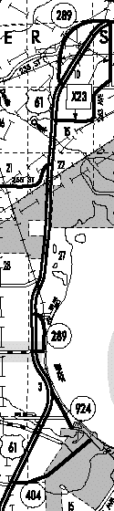
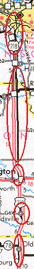
LEFT: Old 61 as IA 289 and 924 between Montrose and Muscatine / RIGHT: All of the segments of IA 923 and, in Henry County, IA 424