Apr 14

Titanic centennial


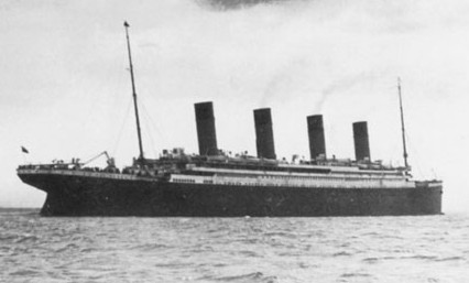
The last 1912 photo of the Titanic, taken by Father Frank Browne

My first encounters with the story of the Titanic were in Robert Ballard’s book Exploring the Titanic in fifth grade and the December 1985 and December 1986 issues of National Geographic. Those two issues detailed Ballard’s discovery of the wreck 73 years after the ship sank.

Since then, my interest has continued nearly unabated. I was a full-fledged buff before The Movie came out and have the History Day project to prove it. At this point, it might be easier to point out which books and videos about the ship I don’t own.

The story has changed subtly in the past 15 years. In the mid-’90s, it was about a technological marvel done in by a cascade of events that all went precisely wrong. Now, it’s about a technological marvel with masked flaws, both mechanical and human, that contributed to and was amplified by that cascade of events.

The Onion’s “Our Dumb Century” went with the headline “World’s Largest Metaphor Hits Ice-Berg” to satirize the event. But it’s really true. The Titanic is one of those things that can be applied to fit many different scenarios, in part or in whole. It has invaded our collective psyche. Think about the political cartoons that always show their ships sinking bow first, even if the ship in question isn’t explicitly intended to evoke the Titanic. (See also my own comparison to the Big 12 Conference’s [second] near-disintegration.)

It is the “thousand If Onlys,” as Walter Lord put it, that help create such a compelling story. The actions of the various groups and classes of people involved throughout the entire story turn into a microcosm of not just the early 20th century, but human nature. There is heroism and cowardice, love and anger, and sacrifice. It’s a parable about misplaced faith in technology and how you never, ever say “God himself could not sink this ship.” If the Titanic did not exist, we would have to invent it.

Centennial links:

National Geographic, April 2012
Why we’re still learning the lessons of the Titanic (Popular Mechanics)
Brucemore Explores Iowa’s Connection to the Titanic (KCRG)

A YouTube user re-edited parts of the 1997 movie to form a “real-time” version of the ship’s last five minutes. (Some frames are flipped as well, and it’s in black and white.)
Posted in Uncategorized | Comments Off on Titanic centennial
Apr 14

Photos by the numbers: 164

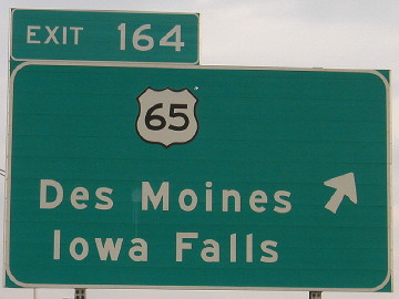
April 9, 2004: Once US 30 was expanded to four lanes around Colo, an exit tab was added to this sign. The interchange was constructed along with the realigned 30 in the 1960s but tapered back to two on either side. Finally, finally, the four-lane 30 was extended east of this interchange in 2010.

When the exit tab was added, though, it was put on the wrong side. As a right-hand exit, the tab should be on the right side. This was eventually corrected.

This sign mentions Des Moines although eastbound 30 traffic headed that way mostly would’ve exited at I-35. Either way, it’s the next major city south.

Posted in Sequences | Comments Off on Photos by the numbers: 164
Apr 13

Photos by the numbers: 163

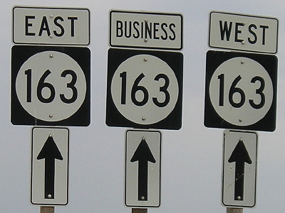
May 31, 2005: Business 163 passes a stub of old IA 163 to meet the west end of the Pella bypass.

Posted in Sequences | Comments Off on Photos by the numbers: 163
Apr 12

Photos by the numbers: 162

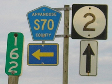
September 13, 2011: Mile markers on wooden posts are rare in Iowa, but here’s one, in Appanoose County, at what was an end of IA 142. Just to the south is a short segment of old IA 2, which separated from the current route about a mile behind the camera. Note of middling interest: A driver heading east on 2 across the state would have seen the last McDonald’s more than 100 miles back, with the next one 10 miles ahead in Centerville. The next one after that is another 90-plus miles east in Fort Madison.

Posted in Sequences | Comments Off on Photos by the numbers: 162
Apr 11

Photos by the numbers: 161

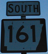
December 28, 2001: AR 161 at I-40 just east of I-30. It is one of the pre-freeway segments of US 67 in central Arkansas.

Posted in Sequences | Comments Off on Photos by the numbers: 161
Apr 10

945* (Update: Still 946)


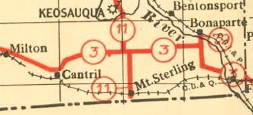
Clip from the first state highway map (1919)

When the Iowa highway system was created in 1920, Mount Sterling was important enough that it (or the Missouri border just south) was the south end of IA 11. That only lasted four years, though, until the connection to Missouri was moved to the road south of Milton. That connection eventually became the south IA 15. The Iowa Highway Commission briefly considered making a spur connection to Mount Sterling — one of the first additions to the original system — but it never was put into effect.

On Wednesday, Mount Sterling, the 14th-smallest incorporated place in Iowa, will cease to exist as a town. News reports say it will be the first to disincorporate since Littleport in 2005, but that is only if Searsboro’s has not gone into effect. (Those two would leave 945 incorporated Iowa towns.)

Mount Sterling, Iowa: 1907-2012.

EDIT/UPDATE, April 12: The current tally of incorporated Iowa cities remains 946. “The county wouldn’t take us,” Searsboro’s mayor says. The title, but not the link, has been updated accordingly.

Posted in Geography, Iowa Miscellaneous | Comments Off on 945* (Update: Still 946)
Apr 10

Photos by the numbers: 160

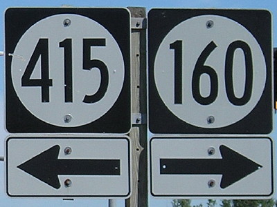
July 23, 2008: West end of IA 160 in Ankeny. The entire route has been inside Ankeny’s city limits nearly since creation. It was originally a connector between IA 60 and US 69, but has moved off that original piece.

Posted in Sequences | Comments Off on Photos by the numbers: 160
Apr 09

A Civil War clarification

In commemoration of the 105th anniversary of the Battle of Shiloh (April 6-7, 1862), in which many Iowa soldiers died, historian Timothy Walch corrects a statement that many people, including myself, had believed to be true. It’s reprinted here for the record. Walch’s full piece can be read here.

For generations thereafter, Iowans would proudly brag of having shouldered more than their share of the burden. Some went so far as to claim that, per capita, Iowa had sent more soldiers to the war than any other state in the Union. Unfortunately, that boast was not true. In his award-winning book, Bright Radical Star, historian Robert R. Dykstra gives credit to Iowa for sending nearly half of its prewar white military-age population off to war. He also adds, however, that four northern states had higher percentages of service per capita than Iowa.

The Centerville Daily Iowegian wrote about Iowans’ participation in a re-enactment of the battle.

Ulysses S. Grant had ordered the Iowans to hold their position at all costs. They did, for six hours — enough to enable the Union to organize its lines and win the battle the next day.

This is a timed post.
Posted in Iowa Miscellaneous | Comments Off on A Civil War clarification
Apr 09

Photos by the numbers: 159

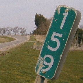
April 9, 2004: Old MM 159 for old US 6 east of Colfax. A few miles ahead, past these curves, is Exit 159 for I-80.

Posted in Sequences | Comments Off on Photos by the numbers: 159
Apr 08

Photos by the numbers: 158

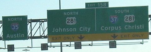
January 26, 2012: I-35 at the north end of I-37 in downtown San Antonio. This picture is one tiny piece of this complex interchange. At this point, we’re not even a third of the way up I-35 in Texas. I-37, meanwhile, is one of Texas’ three two-digit in-state interstates (27, 37, 45).

Posted in Sequences | Comments Off on Photos by the numbers: 158