Oct 08

School timeline mega-update: 1966-67


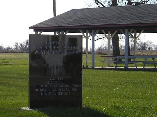
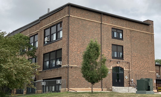
November 15, 2013: “Hayesville Independent School, West Lancaster #9, Est. 1897, Closed 1966, Added to National Register of Historic Places 1990; Memorialized 2011.”

The modern school district era in Iowa began on July 1, 1966. Starting with the 1966-67 school year, the entire state was supposed to have been reorganized into K-12 districts — 455 officially, including the newest, Dysart-Geneseo in Tama County.

It didn’t quite work out as planned. There was a big dash to the finish, but sometimes voluntary reorganization didn’t work, and county boards of education had to make the final decisions. If the disputed area was involved in court proceedings, everything was frozen in place.

I am not chasing after the last one-room or two-room school in every county, although that’s an interesting idea. However, any active in 1966-67 or 1967-68 are somewhat noteworthy, because they were the last remnants of the old system.

  • A smattering of unattached districts between St. Ansgar and the Minnesota border got assigned to St. Ansgar in 1966 (Mitchell County Press-News, 4/21/66). This resulted in the closure of the Otranto building.
  • Holland was attached to Grundy Center in 1966 (Grundy Register, 4/7/66). The school building was sold to the town before the school year ended and the district leased it back until the end.
  • Hayesville’s school closed in 1966, based on the monument placed at the site after its demolition in 2011 (see above).
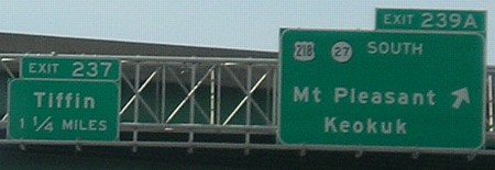
  • In the Howard-Winneshiek district, Chester’s school closed during the 1966-67 school year, per the Lime Springs Herald‘s extremely helpful breakdown of what grades were going where (8/18/66; 10/5/66). A new school in Lime Springs, which closed in 2015, opened to replace one that partially burned in 1960 (Cresco Times Plain Dealer, 4/6/60). A replacement school in Ridgeway opened in the second half of the 1966-67 school year, resulting in seventh-graders shifting towns three times, Chester to Lime Springs to Cresco (CTPD, 12/28/66).
  • The school in Shipley, about 3 miles southwest of Nevada, was closed in spring 1967 before the year ended (Nevada Journal, 4/15/67). The building, old enough to have been a sight on the original alignment of the Jefferson Highway, and its later gymnasium remain intact and maintained.
  • Owasa, in Hardin County, fought until the bitter end, when the Iowa Supreme Court unanimously ruled that the state had the power to delegate final consolidations to county school boards (Cedar Rapids Gazette, 3/8/67). The district was divided 54.64% to Eldora, 31.55% to Iowa Falls and 13.81% to Hubbard (Waterloo Courier, 11/6/67).
  • East Union, which formed in 1959, acted as a two-high-school district until closing Lorimor’s high school in 1965 (Winterset Madisonian, 3/24/65). It closed the Shannon City school in 1967 (Madisonian, 12/14/66).
  • The school in Numa, which in the 1940s was one of the state’s girls’ basketball powerhouses, closed in 1967 (Centerville Iowegian, 1/25/67). So did the “Thirty” school, the last one-room school in Appanoose County.
  • Despite plans to reorganize in 1965, the Carroll Community School District didn’t solidify until 1967 because of a court case, and parts of Carroll County were not figured out until weeks before the 1968-69 school year began (Carroll Daily Times Herald, 9/8/65, 8/31/66, 7/3/67, 5/4/68, 8/6/68). Among the consequences, Templeton’s area was split between Carroll and Manning, and Dedham’s area was split between Carroll and Coon Rapids. However, both were only maintaining kindergartens. Parochial schools, plentiful in the area, skew both enrollment statistics and my ability to track closures, so I’m going to pass. Sorry, towns in Carroll County.
    • But I do know that Dedham’s school was torn down in the summer of 1972 (DTH, 5/2/72).
  • The Carroll issue tied up a chunk of the 19 districts reported as being in non-high-school areas as late as spring 1968 (Cherokee Courier, 5/29/68). Another batch in Kossuth County, including the town of Bancroft, was assigned to Swea City (Swea City Herald, 3/21/68). Of the rest, Marion No. 4 in Marshall County was involved in litigation over being mostly assigned to Marshalltown instead of Green Mountain (Garwin Sun, 1/6/67).
    • North Kossuth moved its middle school to Bancroft in 1993 following St. John’s elimination of grades 6-8 (Bancroft Register, 3/3/93; Algona Upper Des Moines, 8/26/93).
Posted in Schools | Comments Off on School timeline mega-update: 1966-67
Oct 06

Back to the drawing board

The Iowa Senate dropped more work on the LSA yesterday by rejecting the first proposed redistricting maps. The above map wouldn’t qualify for what the agency has been ordered to come up with — a total variance of less than 99, since each map must be better than the previous. But it’s very hard to get one district less than 99 off the ideal, let alone four of them.

Whether the first set was rejected for putting Linn and Johnson counties in the same congressional district or for creating too many incumbent-on-incumbent matchups in the Legislature, well, you’ll have to ask the state senators.

(In Mock 24 I could come up with two districts with variances of 60 and -2, but kept busting on the other two, usually around Kossuth County.)

Posted in Maps | Comments Off on Back to the drawing board
Oct 04

Traer bridge once carried IA 58


September 13, 2021: The 1st Street bridge over Coon Creek is used to get to the Traer airport, although “airport” is generous for the grass strip. In deep background is an old elevator damaged (I think) in the 2020 derecho.

The September Iowa DOT letting included a contract to replace the 1st Street bridge on the east edge of Traer. The contract was let by the state as part of the Federal-Aid Swap Policy, hence “swap” in the project code. (See also here.)

The bridge is a classic pony truss from 1914. This type faded out when the Iowa Highway Commission standardized reinforced concrete bridge designs in the 1920s. Those that remain are rapidly vanishing from rural roads, as even with low traffic numbers the structures are over a century old.

This particular bridge was once part of the Iowa highway system. Primary 58 used this bridge and road (170th Street) to head out of Traer toward Vinton until 1928. I am not 100% sure which street 58 used to switch from 2nd to 1st, though I presume it’s Taylor, the easternmost.

As early as September 1924, there was talk of getting a new route out of town, after a flood wiped out a bridge to the Chicago & North Western depot (the “Ole Depot”, extant today). The Traer Star-Clipper said the new road “would run from the Axon corner through the Sieh land and entering town on Second instead of First street.” Because the landowners in question are long gone, we must consult our friend the county atlas, the ancestor of our friend the plat book.

Here, we can see the first route east of Traer in an arc across the middle of this 1926 Perry Township map clip, along with the Sieh and Axon land. (The “town” of West Union was long dead, even in 1926, and is now a couple houses northeast of the North Tama Athletic Complex.)

The first of two realignments took the highway away from the 1st Street bridge. The new now-IA 8 was completed early in 1928, paralleling the Rock Island Railroad but then heading east on the half-section line through Section 11 (the line/road under the words “West Union”). The remaining diagonal to the bottom of Section 11 and then east didn’t come until 1941.

The 1st Street bridge will be replaced next spring, in its 108th year.

Posted in Tama County | Comments Off on Traer bridge once carried IA 58
Oct 01

Louisa County stops paying the ferryman

The distinction between farm-to-market and local roads once mattered to a great degree in highway systems. Even now, the designation is maintained, and the former is described as roads that “provide all-weather routes to destination points”. So when a county wants to “demote” and “promote” its roads, the state still has to give approval.

Louisa County did some of this recently. From the Burlington Hawk Eye:

The 5.5 miles proposed to be removed from the FM system will include a combined section of County Road X71/River Road northeast of Oakville. The road originally provided access to the ferry that operated between Louisa County and New Boston, Illinois, until it ended operations about 45 years ago.

Unpaved X71 is marked on the Louisa County map, dead-ending at the mouth of the Iowa River. It’s also shown as an FM road on this FM-specific map from 2011 that shows X61 on the Great River Road not quite finished yet.

In 1948, the Cedar Rapids Gazette said the ferry service was 130 years old, which would date it back to approximately Illinois’ statehood. The operator expected to end the service that winter, but something must have happened to keep it going. A short item in 1952 said thieves stole two of three ferry boat motors, and gave a different name for the operator.

A 1979 Gazette article referring to “the old ferry landing” leads with a historical nugget about the Cedar River: Its abrupt turn southwest at Moscow to Columbus Junction is based on ancient stream beds of the Mississippi on the west edge of the Illinoian Glacier. (Note the small incursion of the glacier into southeast Iowa on this map.)

The Hawk Eye article says part of the local/FM balance will be maintained by adding G36 southeast from X17 to Columbus Junction, which is currently unpaved. The rest of the addition is one mile of gravel from Oakville along the Iowa River to X99. This segment was part of IA 99 until a slight bypass of Oakville was built in 1955. The bypass itself was graded in 1941 according to the DOT document archive, and the 1945 county map shows “F.A.” for Federal Aid on the 1¼-mile bypass curve, but I seriously doubt the dirt road would have been signed as 99 at that time. At the very least, it was 99 in 1931-41.

(Title reference.)

Posted in Highway Miscellaneous | Comments Off on Louisa County stops paying the ferryman
Sep 29

Bella Vista bypass opens this week

One of the Midwest’s longest-promised highway projects that never seemed to get off the ground for years is opening this week.

The Bella Vista bypass will go across the Arkansas-Missouri state line and create a full four-lane I-49 from Fort Smith to Kansas City. Stories: KATV, KHBS.

The ribbon-cutting will be Thursday, and the interstate will be open Friday.

Posted in Highway Miscellaneous | Comments Off on Bella Vista bypass opens this week
Sep 28

It is the children who are wrong

The Verge: 

Gradually, Garland came to the same realization that many of her fellow educators have reached in the past four years: the concept of file folders and directories, essential to previous generations’ understanding of computers, is gibberish to many modern students.

But if students don’t understand directories, how can they create folders to hold images for their … oh, right, no one makes websites anymore.

Heaven help us if they ever encounter a C:\ prompt.

“As much as I want them to be organized and try for them to be organized, it’s just a big hot mess,” Vogel says of her files. She adds, “My family always gives me a hard time when they see my computer screen, and it has like 50 thousand icons.”

I think my brain just kernel panicked.

Posted in Uncategorized | Comments Off on It is the children who are wrong
Sep 27

Notes on first 2020s redistricting map

So, I didn’t win Redistricting Powerball. Oh well. Ironically, my very first map based on 2019 population estimates — and, to a lesser extent, Mock 21 — came closest to pegging the new 1st District. The overall variance is 99, slightly better than my 151 in Mock 23. Here’s the link to the LSA site.

IMO, it’s misleading to treat “old” and “new” districts with any sort of continuity. The “new 1st” retains only two counties of the old 1st, Linn and Jones. Despite that, the 538 website managed to mis-assign Ashley Hinson to the new 2nd and Mariannette Miller-Meeks to the new 1st. (MMM is at the very bottom of the new 2nd.) However, because of the nature of Iowa districts, it’s easy to compare county clusters, and their previous statewide-election partisan breakdowns.

From a map perspective, it’s very interesting to draw comparisons with the third 1981 proposal, the first set under the new system and only one so far to go to a third map.

  • Anything with Linn and Johnson together creates a district friendly to Democrats. And, as John Deeth points out, “Johnson and Linn are a self-contained unit of 12 House and 6 Senate districts.” That’s basically half a congressional district.
    • But then, if “split Linn and Johnson” is an unspoken wish/demand from the Legislature, and it’s the one thing the LSA won’t/can’t do, it could get ugly. My Mock 14, 17, and 17A each fit the bill, but with variances in the hundreds, and Iowa Code specifically states that the second plan cannot be worse.
    • One of the photos on Page 33 of this report looks awfully familiar
  • The only other “self-contained unit” runs across 14 counties at the Minnesota border — but contain only 6 House/3 Senate districts.
  • Polk and Dallas counties make up three-quarters of the population in the proposed 3rd Congressional District.
  • Senate Districts 7 (all or part of Madison, Adair, Guthrie, Greene counties, plus half each of Carroll and Dallas) and 47 (Camanche to Peosta) are the two congressional-district jumpers.
  • Tama County and Wapello County (Ottumwa) have only been together in a congressional district twice before: the 1860s and the 1960s.
  • Tama County’s proposed state House district is remarkably similar to its 1990s House district, with northern Benton County and part of Black Hawk. However, this time, the companion district is southwest to Marshalltown instead of southeast to Iowa County. Each House district can keep a current representative (Dean Fisher of Garwin, Sue Cahill of Marshalltown).
  • Tama County’s proposed state Senate district would be an open seat in 2022.
  • In the 1980s, Mason City, Burlington, and Clinton were all just a smidge too big to be their own House districts (as were Marshalltown and Fort Dodge in failed maps). Now, though, each needs to pull in surrounding areas to create one. Council Bluffs and Dubuque were each “two plus a little” and remain roughly so.
  • Have I mentioned Waukee’s city limits are outrageously absurd? Because Waukee’s city limits are outrageously absurd. Ditto for Carlisle.
  • Ankeny now has an entire state Senate district to itself, and Marion makes up 3/4 of one. (And have I mentioned Ankeny’s south city limits are outrageously absurd? Did the Census Designated Place of Saylorville set up a force field?)
  • Coralville and North Liberty, plus a bit of Iowa City, pretty much make up a Senate district as well. This ends the greatest political buddy comedy that never happened, a pairing of Republican Bobby Kaufmann and his state senator, Democrat Zach Wahls.
  • Proposed House 39 and present House 40 are identical: Urbandale, minus a chunk between 72nd and 86th streets. In the 1980s, one House district could hold Clive, Urbandale, and Windsor Heights.
  • Follow IA 4 and IA 25 from top to bottom and you’ll only hit four state Senate districts.
  • Extremely tangential note: Jefferson County did NOT surpass its 1870 population. In fact, it hit its lowest population since 1940. Only part of that is due to Maharishi Vedic City appearing to nearly vanish, losing 1000 people from 2010.
  • Anyone say anything about Illinois? Does the New York Times know the Illinois Legislature exists?
Posted in Maps | Comments Off on Notes on first 2020s redistricting map
Sep 24

Third loop at I-80/380 going away


March 12, 2007: When IA 27 was created, signs on I-80 were retrofitted with mini-shields to save space. It’s this exit that will be going away next week. The Tiffin exit will serve as the turnaround.

The first loop ramp to go at the I-80/I-380 interchange was the most important one, eastbound 80 to northbound 380. The second was northbound US 218 to westbound 80.

Monday night, a third loop is being closed permanently: westbound 80 to southbound 218. Both it and the previous loop closure will require going past the interchange to the next exit (Forevergreen Road and the Tiffin exit, respectively) and turning around.

Both exit movements will not be restored until the end of the 2023 construction season, a full two years-plus from now.

The only loop remaining after next week is southbound 380 to eastbound 80.

Tuesday morning, the “exit point” from westbound 80 to northbound 380 will be moved ¼ mile east, closer to the Coral Ridge onramp and approximately at 80’s bridge over US 6 and the railroad based on the DOT’s explanatory map.

Posted in Construction | Comments Off on Third loop at I-80/380 going away
Sep 22

It’s 941, not 939

I should have said something earlier. I should have said it when I made a post about it.

The two Nebraska students who visited “all 939” towns in Iowa this summer — and got another article in the Register — MISSED TWO OF THEM. But I can’t tell them directly, because I don’t do Facebook, and there’s no way for me to know which two fell off their list.

The 2020 census numbers, directly from the State Data Center, show that on April 1, 2020, there were 942 incorporated places in the state. Pioneer, in Humboldt County, was formally disincorporated in August, so right now there are 941 incorporated places, not 939. This number matches previous posts I’ve done about cities that disincorporated.

I cannot link to the 2020 population list because the State Data Center does an interactive thing that requires changing parameters. (It should not be hard to get raw data!) I can, however, link to my PDF from 2011 that clearly shows there were 947 cities at that time. That’s the list I used, crossed with the state map, on my quest that ended in 2016. Six have been discontinued since.

But I have to say something somewhere, because there are 941 cities in Iowa in 2021, no matter what their book title says.

Posted in Iowa Miscellaneous | Comments Off on It’s 941, not 939
Sep 20

Razing 1917 building an option for North Tama

WAIT WHAT


July 7, 2021: North Tama’s 1917 school building, as seen from 7th Street in Traer. The concrete steps to the door are relatively new and used to have tannish-orange edges like you see lining the bottom of the bricks. The windows were replaced in 2010, and the entire complex got air conditioning of some sort in 2015.

It started as an innocuous forward-looking press release in March. “North Tama School officials recently announced that the district will engage in a formal process to ensure the district’s facilities are equipped to meet the needs of students in the coming decades.”

Then, three weeks ago, things really ramped up.

Closing Walnut St, razing 1917 building among the options considered at North Tama special board work session

WHOA. This was definitely not on my radar. As usual, never assume I’m in the loop; in fact, assume I am unaware of the existence of the loop.

The North Tama Telegraph says the options have been narrowed to three. Two would involve the permanent closure of Walnut Street, which I don’t particularly like, for new elementary construction to the west. Two would result in the demolition of the core 1917 building — the three-story structure plus the present cafeteria and expansive Family and Consumer Sciences area. (Ironically, none appear to include acquiring the property at 606 Main St. that blocks filling the block.) A video recording of the meeting is available here: Plans 2, 4, and 6 are the ones advancing.

None of the three plans currently include an auditorium or a new competition gymnasium to augment the 65(!)-year-old one, which would become the oldest part of the complex. A true auditorium has been a dream of some in the community for decades, perhaps ever since the one integrated into the 1917 building was chopped up into classrooms.

Imagine baking multiple cakes in pieces of various shapes and heights, sealing them together with frosting, and then trying to cut the tallest portion plus another chunk of the center out without disturbing the rest of the cake. That’s what we’re talking about when it comes to the 1917 building in Traer. The closest parallel I can think of is Newell-Fonda announcing earlier this year it’s considering demolition of its original core building. When Hudson did it two decades ago, the oldest structure was basically a corner piece.

Construction of the 1917 building, which opened in the fall of 1918 and was dedicated January 31, 1919, had a larger than expected cost: $105,000. “The prices of everything these days are abnormally high,” the Traer Star-Clipper said July 6, 1917. After all, there’s a war on.

The gym addition with stage, band room, and locker room cost $227,000 ($185,000 bond plus cash on hand, opened winter 1955-56); the elementary plus stuff east of the gym cost $500,000 in 1963 (opened 1964). Another $500,000 bond issue in 1979 formed the FCS area (then “home ec”) over the original gym-turned-cafeteria and added an industrial arts area — after a $1 million version including an auditorium was shot down twice. A $380,000 bond issue in 1996 cleared the way for the multipurpose room and kindergarten on the north side in 1997. There are also minor additions to the south (1940) and north (1957) sides of the original gym/cafeteria before the large 2010 expansion on the north side.

The two more extensive options in the 2020s, which would take down the 1917 building and replace it with a single-story addition, are currently estimated to cost between $30 million and $35.5 million. I would miss it very, very much; after all, it’s what kindled my love and respect for that style of building. I’m in the group of rural Iowans that has not known either consolidation or building loss in my home district since graduation. Removal of the oldest part of the school, one generations have known inside and out, would be a gigantic change for everyone. Will I need to hug it goodbye?

(Sources: Cedar Rapids Gazette, 10/10/54, 12/18/55, 3/12/57, 1/7/63, 9/10/78, 3/4/92, 6/26/96; Waterloo Courier, 2/15/78, 5/20/79; Traer Star-Clipper, 6/15/17, 7/6/17, 1/31/19, 8/16/40)

Posted in Schools, Tama County | Comments Off on Razing 1917 building an option for North Tama