
[rant]
WHY IS NORTH TAMA WEARING BLACK PANTS
BLACK IS NOT A NORTH TAMA COLOR
WHY CAN’T ANYONE WHO DOESN’T HAVE BLACK AS A SCHOOL COLOR BE HAPPY WITH THEIR UNIFORMS
[/rant]
But hey, big Homecoming win.
[rant]
WHY IS NORTH TAMA WEARING BLACK PANTS
BLACK IS NOT A NORTH TAMA COLOR
WHY CAN’T ANYONE WHO DOESN’T HAVE BLACK AS A SCHOOL COLOR BE HAPPY WITH THEIR UNIFORMS
[/rant]
But hey, big Homecoming win.
August 16, 2016: “There will be an informal opening of the new gymnasium at the Sharpsburg school on Saturday evening, October 10, at 8:00 o’clock [sic]. A snappy program is planned, followed by a lunch consisting of sandwiches, pie, pickles and coffee.” — Lenox Time Table, October 8, 1936
“The exodus of high school graduates from the county has become so universal that Mount Ayr high school seniors were given a special guest lecture this year on urban living.” — Des Moines Register, May 24, 1970
Everything Many things you wanted to know about the United and Mount Ayr community school districts, but didn’t know how to ask:
UPDATE 1/21/22: Adjusted Beaconsfield based on new information.
UPDATE 5/12/25: Closure of both Benton and Tingley in 1980 confirmed via Record-News, 4/17/80 and 5/15/80. But Ellston was only used for one year, and a fraction of a year at that, before classes were moved to the basement of the otherwise-demolished 1912 building in Mount Ayr (4/13/78).
The old Cafe 218 in Vinton opened shortly after the US 218 bypass of Vinton did. For about a decade, it was vacant. As of the week before Labor Day, it’s gone. Stories: Vinton News, Vinton Today.
The land is going to be used for a relocated Dollar General store, the above sources say. Vinton has one, but this will be a bigger area.
In June, city boards in Dysart cleared the way for a Dollar General to be built there, on IA 21 north of Casey’s, reported the North Tama Telegraph.
Supermarket News, an industry publication, reported in March DG wants to open 1,050 new stores this year, after 1,000 in 2020 and 975 in 2019. CNN in May cited a study that says nearly 1 in 3 store openings announced for this year nationwide is a DG, and 45% a DG, Dollar Tree, or Family Dollar.
Dollar General was called a contributor to the closure of the local grocery store in Manson and called a threat to the one in Kingsley by those stores’ owners. Just last month, Story City’s last grocery store shut down, and the owners cited Dollar General there, too.
The Iowa 4-H Hall of Fame honored its class of 2021 on the last day of the Iowa State Fair. I happen to know Tama County’s inductee very well.
(There are now two members of North Tama’s Class of 2000 that have parent(s) in the 4-H Hall of Fame. How many other districts’ graduating classes can say that?)

Mock 22: The I-380, US 34, and US 18 districts
District 1: Pulled from Mock 20 because it’s so good.
District 2: Heavily Republican southern Iowa helps Mariannette Miller-Meeks.
District 3: Long district is long? Good on small area, not great on compactness. It keeps Polk, Dallas, and Story together, though.
District 4: Guthrie, Harrison, and Marshall counties drop down from the main area to form this one, whose variance pushes my self-imposed limit.
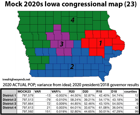
Mock 23: Put a blue ribbon on it?
District 1: This county combination makes its third appearance.
District 2: The Shelby-Audubon-Guthrie extension here is this map’s biggest weakness. But my only other options are Cass, Montgomery, and Mills, and they just don’t work out numbers-wise.
District 3: Shades of the 1960s 5th District, bringing Des Moines, Ames, and Fort Dodge together, but with more surrounding land. This time around, though, Fort Dodge isn’t even in the district’s top five cities.
District 4: This is a wraparound of Iowa’s northern and western thirds, from Lansing to Larchwood to Lewis. But despite its sprawl, and large perimeter, look at that variance.
This map, number-wise, is nearly as good as the LSA’s second 2000s map, the one that was approved. This map has potential, though I wouldn’t be surprised at something closer to Mock 14 or Mock 17A for geographic-size-equality reasons. I’m absolutely ending with this one.
The real maps come out Thursday.
UPDATE 9/22: Fixed slight Scott County population error. This brought the overall variance up slightly, but it’s still pretty dang good.
“It should never be forgotten”: Traer family puts 2,997 flags in front yard in honor of 9/11 victims (KWWL)
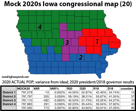
Mock 20: Corridor compaction
District 1: Democrat Liz Mathis has a clear-the-field list of endorsements for whatever district includes Cedar Rapids. Christina Bohannan — who primaried a long-time representative in Iowa’s most Democratic state House district — has received former U.S. Rep. Dave Loebsack’s endorsement for whatever district includes Iowa City. So what happens if Iowa City and Cedar Rapids get smushed together in my third-best individual mock district? (Local note: Iowa and Tama counties are, by a decent margin, the smallest here.)
District 2: The bulk of the population here is on the east end, but the spread provides a seriously safe R seat.
District 3: Hey, a Des Moines-based district that doesn’t touch a state line!
District 4: Extremely safe R, perhaps mitigating the spread across four media markets. After Woodbury County (Sioux City), Dallas is the second-most populous, then Cerro Gordo (Mason City), and numbers 4-5-6, Boone-Bremer-Plymouth, are widely distributed.
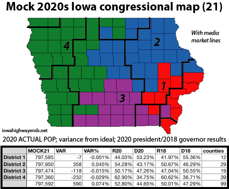
Mock 21: Republican trap
District 1: Ashley Hinson would face a mountain with many counties outside the KCRG viewing area, reducing name recognition.
District 2: An open seat ripe for a Waterloo-based candidate. (Former Rep. Abby Finkenauer, D-Dubuque, has her eyes on the Senate in 2022.)
District 3: Again, just like my very first map, an incumbent-on-incumbent battle with Ottumwa and Des Moines together. Henry County sticks out very awkwardly here.
District 4: A wraparound to Mason City and a jut into Creston. This is one of my more western-oriented 4ths, the district that almost always was “the rest” after creating the first three.
I don’t know if it’s a personal oversight or just the way the numbers break, but I ended up with more river-t0-river (E-W) than border-to-border (N-S) districts. See Mock 20, above. At the same time, I’ve always started working outward from Des Moines and the Linn/Scott areas, and once I do that, it gets very difficult not to just start plugging in the lower-population counties heading westward.
UPDATE 9/22: Fixed slight Scott County population error.
Mock 15: Checking Wasserman
The great thing about Iowa’s congressional districts is that anyone can play. I did some looking at what the “professionals” were playing with. I made Mock 15 based on this tweet from Dave Wasserman of the Cook Political Report, and immediately noticed an issue: There’s a variance of more than 1000 between the 1st and 2nd districts. I’ve already done better than that — twice — and in fact I don’t go forward with any simulation that exceeds 1000 in variance.
I do not think the map that won Wasserman’s redistricting challenge would fly with the LSA. Its overall variance of 5 is outweighed by the exceptionally jagged outline of the 2nd District and the way the 4th wraps around the 3rd.
(Mock 18 was also related to the maps in the tweet thread, and it had an overall variance of 513, not bad at all.)
Mock 16: Busting out along US 30
I got two pretty decent districts, but I busted hard on the Benton-Linn-Cedar-Scott area. I mentioned this as a pitfall when I was working with previous estimates in Mock 3. Once a new 3rd goes from Des Moines to the Missouri border, everything left in the bottom tiers has to pour into a new 2nd, and their aggregate is enough for a map to get a Whammy once I reach the US 30 or I-80 corridors.
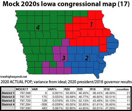
Mock 17: The Creston curl
1st District: LOOK AT THAT 1ST DISTRICT. IT’S SO PRETTY. Sadly, it cannot be combined with my 3rd District from Mock 13, also with a single-digit variance, because everything southeast of them makes a too-big 2nd.
2nd District: A pretty good, decently competitive district with nice lines.
3rd District: What otherwise could be an exceptionally tidy district focused on the Des Moines metro — and one of my few mocks that doesn’t make Story County hate me — hiccups at Union County, which is bigger than its neighbors. Thus, I had to go around the city of Creston by adding three of Iowa’s four smallest counties by population: Adams, Ringgold, and Taylor. That’s this map’s weakness — a one-county-wide section leading to two above and four below isn’t ideal.
4th District: A sprawler containing nearly half the counties in the state.
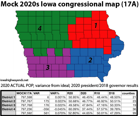
Mock 17A: The Hubbell-Trump map
I love the previous map’s 1st, but it also locks everything northeast of Washington County into the 2nd, and that’s a big chunk of population. This limits possibilities to the west. However, by throwing Story County back in with northwest Iowa again, I got a map that is roughly the same variance-wise, but much more balanced area-wise.
This is an insanely politically competitive map. In all but the 4th, the candidates in the last two statewide elections fell between 46% and 51% of the total vote in these particular county combinations. In fact, 2018 Democratic candidate for governor Fred Hubbell comes out ahead of Gov. Kim Reynolds in three districts — but all three also went for Donald Trump over Joe Biden in 2020.
The 3rd and 4th dovetail with each other, which adds to perimeter but isn’t horrible on compactness. (Shelby County is 1100 people bigger than Guthrie, not much but enough to spill over my 1000-variance district threshold.) The much bigger issue is the separation of Dallas and Polk counties. The grouping or splitting of Polk/Story/Dallas and Linn/Johnson will be the deciding factors in the next decade of Iowa’s congressional delegation.
Mock 19: Self-imposed bust
The individual districts were fine, but the margin between the biggest and smallest was about 1200. As noted above, I didn’t follow through.
UPDATE 9/22: Fixed slight Scott County population error.
(Through September 1, 2021. Updates will be marked as needed for the 2021 season.)
The timeline is now going so far back I’ve found buildings I didn’t know existed, in map dots that either aren’t on the state map now or were never there.