Jul 12

Vincent school building to be torn down

I featured the Vincent school building in my alphabetical series (which is still going on; just search the Sequences category). It didn’t look in good shape. It turns out the building is indeed abandoned and the town has been awarded $50,000 from the DNR to tear it down. Ironically, it’s one of the few entries on the DNR list that doesn’t include the word “asbestos”; perhaps it’s automatically understood to be part of the “deconstruct” line.

Posted in Schools | Comments Off on Vincent school building to be torn down
Jul 11

US 63 to be closed north of Traer

The Iowa DOT has announced that US 63 is going to close north of Traer on July 25 to replace the deck on the bridge over 12 Mile Creek. Traffic will be detoured on IA 8, IA 21, and D52. The bridge doesn’t look like it should need a fix, but that’s what it says on the card.

(Those who aren’t afraid of gravel need only take a 3-mile detour.)

I can hope, but have no expectation, that putting up the detour signs will result in getting rid of the incorrect “Jct 21” on westbound 8/northbound 21 that’s been there since 1998. (See the bottom of the IA 402 page.)

Posted in Construction, Tama County | Comments Off on US 63 to be closed north of Traer
Jul 08

L is for Lovilia


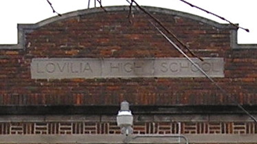
November 12, 2008: Lovilia school building (1920) and closeup, below.

Brian McMillin of Iowa Backroads wrote some history of the Lovilia school on his blog. Two State Board of Education documents tell a fuller story about the end of the Lovilia school, which remained open as part of the Albia district until the end of 1998. In a special session after less than 72 hours’ notice (Iowa requires 24) on December 4, 1998, the Albia school board voted for a “temporary” closure of the building after the boiler failed. The state board soon ruled that this was an obvious fig leaf to avoid school-closure guidelines, given that everything was moved out of the building over Christmas break and the boiler was shut down.

Unfortunately, it was a pyrrhic victory. The state board’s decision came in the middle of the spring semester, too late to move the students back, and it gave Albia time to follow the real procedure. After multiple, well-published, well-attended meetings, both Lovilia and Melrose were given the ax on March 9, 1999, and this time there was nothing the state could do about it.

Posted in Schools, Sequences | Comments Off on L is for Lovilia
Jul 07

Benton 30-218 interchange moves forward

On June 30 the Iowa DOT held another meeting about converting the US 30/218 intersection in southern Benton County into an interchange. It won’t be finished until 2019.

The interchange has ramps in the northwest and southeast quadrants to avoid both Youngville Station and a cemetery. The existing roadbed will be shifted southward starting just east of Youngville, so the westbound lanes will gradually shift south of the existing ones until they’re about where the eastbound lanes would be if the two-lane stayed in place.

Along with the interchange plan (PDF), we also got a timeline for completion of four-laning 30 from that location to Tama (PDF). There are four stages: Tama to IA 21, the IA 21 exit, 21 to 218, and the 218 exit. The whole thing is scheduled to wrap up in 2024.

(Totally unrelated FYI: The Forgotten Iowa Tumblr blog has made it to Benton County.)

Posted in Construction, Tama County | Comments Off on Benton 30-218 interchange moves forward
Jul 06

West Des Moines adds quadrants, sort of

Jason Hancock noticed that an exit on the IA 5 bypass in West Des Moines is now Southeast 35th Street instead of just 35th Street. (For a short time after the bypass opened, it had a Polk County designation instead. West Des Moines not adopting the Polk County/Des Moines grid in the 1950s causes headaches to this day.) I did some more digging on the city’s website, and found some more background and a different change to what used to be part of IA 5.

At the beginning of 2015, the West Des Moines City Council started ordinance readings to assign the prefix SE to all streets south of the Raccoon River and east of I-35, and SW to all streets south of the Raccoon River and west of I-35. Only a handful are in the “southwest” — see my blog post from May 2014, “A township that needs to be put out of its misery, but probably can’t” — and only a handful likely ever will be.

The city’s official map, which is dated June 30 but was available before then, has all the new street names and additions. Only SE and SW are added; there are no NE or NW street areas.

The very very very long-term plan for the Greater West Des Moines Co-Prosperity Sphere includes a scheme to link up the Southwest Connector Veterans Parkway with a north-south road nearly all the way by Van Meter. Look out, Cumming.

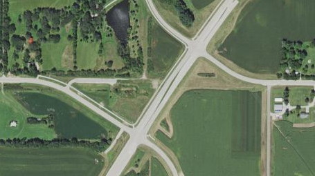
That segues into the other change West Des Moines has made in its southern area — it decided to muck up part of what was left of a perfectly good, straight Army Post Road. As Army Post comes from the west toward Veterans Parkway, the street now turns southeast, to run past the new Microsoft data center and intersect IA 28 nearer its interchange with IA 5. But that meant that the connector (which, for the most part, isn’t connecting much at the moment) intersected Army Post Road twice:


2015 aerial photo via Iowa Geographic Map Server

The city didn’t want that to stand, so it renamed the part of Army Post running east of the parkway Willow Creek Drive — but between the parkway and IA 28, it hits 1st Street, and reverts to being Army Post because we’re back in Des Moines.

The better solution would have been to name it Old Army Post Road, and then persuade Des Moines to do the same for the short portion running west from IA 28. (The street east of IA 28, which still exists until the airport, is named Old Army Post Road.) Only one place in Des Moines — the Baymont Inn and Suites — would have to change its address, the few affected locations in West Des Moines would have an easy change, and there would be continuity between the cities with a callback to the original name.

Posted in Maps | Comments Off on West Des Moines adds quadrants, sort of
Jul 05

Classic, good Mapquest going away

I predicted this was going to happen. A website that I’ve been using since the 20th century is being shut down, and while the name continues, it’s not really the same. (It also may mean that no Internet mapping site is available anymore for older operating systems/browsers.) The green terrain and yellow lines of Mapquest are going to be gone, leaving nothing but a drab landscape ahead.

Beginning July 2016 [possibly July 11 -ed.], you will no longer be able to access this version of MapQuest.com. So, if you haven’t yet, it’s time to check out the new MapQuest.com! With faster loading, sleeker and easier to read maps, along with less intrusive advertising, it’s time to make the move. Plus, you can now access your saved maps and accounts!

The “new” Mapquest learned all the wrong lessons from the Internet mapping systems that followed and usurped it. Most notably, it is very hard to see county lines — I suppose we have to be thankful they’re there at all, because Google continues to be stupid.

While the imagery has changed some since the original website’s inception, this loss should be considered the death of the Mapquest that, despite its foibles, opened up the world of Internet mapping.

Posted in Geography, Maps | Comments Off on Classic, good Mapquest going away
Jul 04

Liberty and law


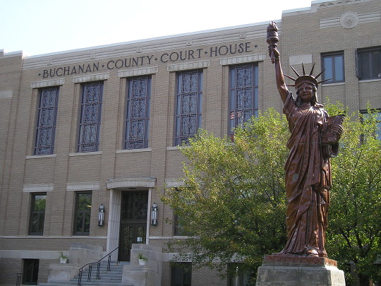
September 2, 2008: Replica Statue of Liberty (1950) outside Buchanan County Courthouse (1939) in Independence, Iowa (1847).

Posted in Iowa Miscellaneous | Comments Off on Liberty and law
Jul 01

Moving IA 17 off Lincoln Highway


July 5, 2013: The original Lincoln Highway runs on IA 17 between E41 and 205th Street in Boone County. The elevator is part of West Central Cooperative.

There is a mile-long east-west segment of IA 17 that runs along old US 30, north of the four-lane, east of Boone. When IA 17 turns north again, there’s an at-grade railroad crossing right at a West Central Cooperative elevator. (The elevator is the last legacy of the town of Jordan.)

At a meeting earlier this week, the DOT presented options to reroute IA 17 in the area. All the options (PDF) have a railroad overpass with new connector to E41/old 30. One option has a gradual curve to line up the segments; the others keep right angles but the east-west segment would be north of the elevator.

The reroute is a good idea. Making IA 17 traffic turn at right angles is fine, and would be an improvement since the existing turn at the elevator is sharper than 90 degrees.

The signed Lincoln Highway Heritage Byway uses the 1913 alignment, crossing the railroad tracks back at R Avenue, going east on 205th Street, then south on IA 17, then east at Jordan, then crossing the railroad tracks again on U Avenue before heading east to Ames on 220th Street. That means it’s a north-south half-mile of 17 that is co-signed with the Lincoln, while it’s the east-west mile that used to be part of US 30. If the new 17 were to use 205th Street as its east-west mile (the “orange concept”), it would be the first time the Lincoln Highway in Iowa gained pavement in a very long time.

Posted in Construction, Highway Miscellaneous | Comments Off on Moving IA 17 off Lincoln Highway
Jun 30

Map of Iowa school enrollment changes, 2001-2015

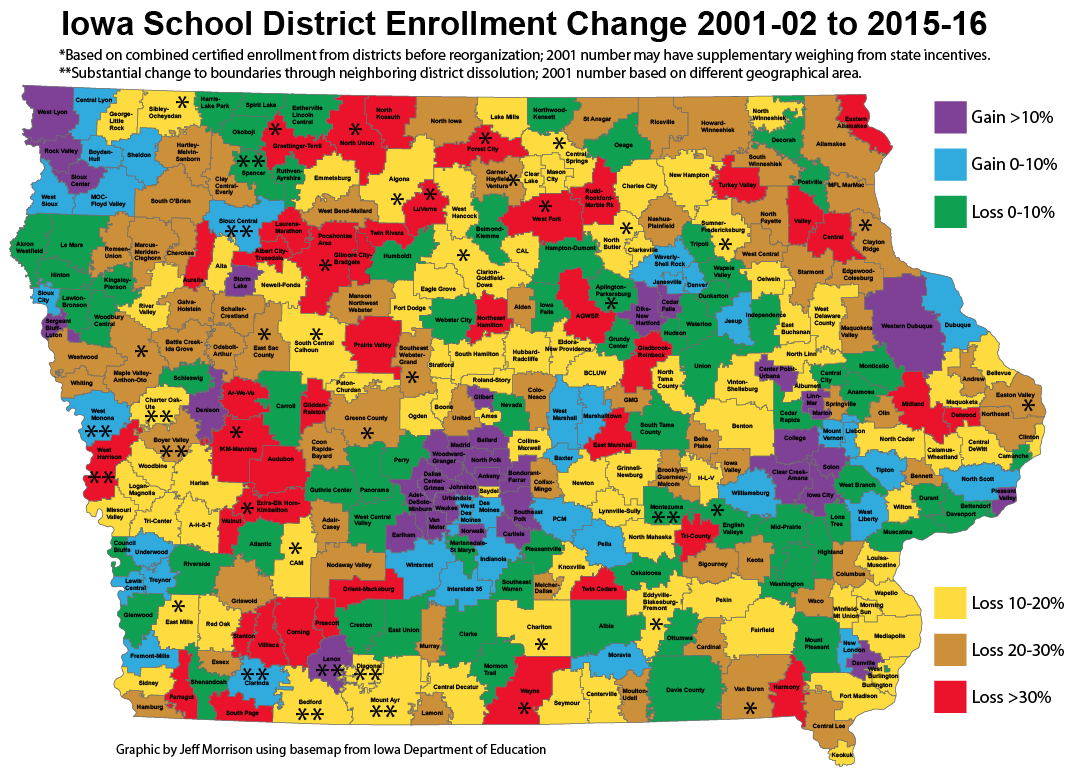
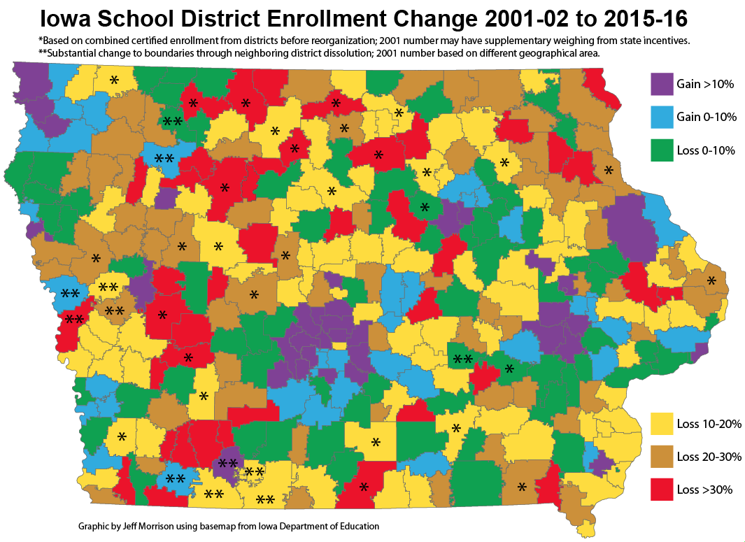
I have created a color-coded map of Iowa that shows changes in certified enrollment between 2001-02 and 2015-16. Certified enrollment is not a direct correlation with head count, because of certain formulas, but it’s the number used for all state purposes. (The best analogy is “official attendance” vs. butts-in-seats at sporting events.) The map shows a vivid representation of rural decline: With red, brown, and yellow showing the worst drops, it looks like a tree in October.

Map of Iowa school district enrollment changes, 2001-15 (names)

Map of Iowa school district enrollment changes, 2001-15 (outlines only)

Nearly all the districts that gained enrollment fell into three categories: Suburbs, exurbs (within about 30 miles of a city), and meat-packing plants (Denison, Marshalltown, Storm Lake, and West Liberty). A cluster of eight in far northwest Iowa is the largest exception. The few others that showed growth: Clarinda, Fremont-Mills, Lenox, Moravia, Sioux Central, and West Monona.

For districts that merged in this time frame, I added together old districts’ certified enrollments from 2001-02. This is not a perfect metric, since state incentives can “add students”, but the differences are so stark I don’t think the overall results are significantly affected. For example, Exira and Elk Horn-Kimballton independently had certified enrollments over 330 in 2001, but today’s consolidated EEHK is hovering around 400. Dissolutions are factored into the remaining districts’ numbers. (Russell and Corwith-Wesley are treated as mergers with Chariton and Lu Verne, respectively, given the overwhelming move of land to those districts.)

Of Iowa’s 336 school districts in 2015, compared with certified enrollments in 2001:

  • 35 gained 10% or more, with Ankeny, Bondurant-Farrar, and Waukee blowing the doors off everyone else.
  • 37 gained up to 10%. The most neutral-enrollment district is also the state’s largest: Des Moines’ certified enrollment changed by a net of 1.5, which is kind of remarkable.
  • 72 lost beween 0% and 10%
  • 85 lost between 10% and 20%
  • 65 lost between 20% and 30%
  • 42 lost 30% or more, including 33 whose boundaries never changed during this time.

While making this map I stumbled on a couple issues relevant to graphic design I thought I’d share:

  • I have six categories, so my plan was for a simple rainbow palette (the U.S. map on my “College conferences and House apportionment” page is like this except ROYPBG instead of ROYGBP). The orange felt too close to the red for a map like this where there are a lot of lines, so I switched to a brownish hue instead.
  • Because I have two positive categories and four negative categories, green is denoting a negative statistic. It’s the least worst (it’s the new “up”!) but since green connotes positive/go/growth, I had to think about it. I didn’t want to use a USA Today-style “shades of blue” set, and even the rainbow runs into issues of red-green colorblindness (as the NFL inadvertently discovered).
  • When maps and graphics were drawn before the desktop publishing era, hatch/line/dot patterns were used to convey different categories of information. See, for example, this map of population growth created in 1921. On such a busy map with detailed, crooked lines, patterns seemed to confuse more than illuminate, and “color-hatching” wasn’t an option. Solids were definitely the way to go.
Posted in Iowa Miscellaneous, Schools | Comments Off on Map of Iowa school enrollment changes, 2001-2015
Jun 29

Iowa’s largest enrollment gainers, 2001-2015

Statewide student enrollment over the past decade and a half tells a different story than a district-by-district breakdown: Rural areas continue to be drained of students while the gains are concentrated in the suburbs.

By the raw certified enrollment total, the state is about 5,000 down from 2001-02 to 2015-16 (489,522.8 vs. 484,378). That is actually a recovery from a valley in 2010. But here’s the change: The top 20 districts by enrollment now educate 42% of Iowa’s students, up from 38% in 2001.

From 2001 to 2015, six districts — Waukee, Ankeny, Iowa City/Clear Creek Amana, Johnston, and Southeast Polk — added nearly 20,000 students while the rest of the state lost 25,000. (I am grouping Iowa City and CCA together because, while Iowa City is much bigger, North Liberty and Coralville are split between them, and it’s the most effective way to get the total growth in the area.)

I was going to give year-by-year enrollment equivalents of these fast-growing districts for the last 15 years, but the lists got quite lengthy. To illustrate what I was going for, Waukee added the entire enrollment of North Tama to its 2003-04 student body, and then added the entire enrollment of North Tama again in 2014-15. Instead, here is the aggregate growth of 15 years and their equivalents. Between 2001 and 2015:

  • Waukee added the entire 2015 enrollment of Johnston, which is on this list in its own right below.
  • Ankeny added the entire 2015 enrollment of Ottumwa.
  • Iowa City/Clear Creek Amana added the entire enrollment of Indianola between them.
  • Johnston added Oskaloosa and threw in Orient-Macksburg for good measure. It’s building a new high school and the existing one will be turned into one for eighth and ninth grades.
  • Southeast Polk added the entire 2015 enrollment of Storm Lake.
  • The next two fastest-growing districts, Linn-Mar and Pleasant Valley, weren’t too shabby either, adding roughly the enrollments of Harlan and Boone, respectively.

As the rural districts drop in enrollment, per-pupil funding shrinks accordingly, and that’s not the only squeeze on the financial end. For a decade the Legislature has put education funding on meager rations — annual allowable growth below 3 percent means expenses outpace the budget. Keeping expenses down means, in turn, keeping salaries down, and the effect of that is that instead of hiring “lifers” small districts become the equivalent of triple-A ball or small network affiliates, a stopover place to pay one’s dues before moving on to a bigger gig. Rapid turnover has its own effects on education.

Posted in Iowa Miscellaneous, Schools | Comments Off on Iowa’s largest enrollment gainers, 2001-2015