Feb 06

License plate countdown — YXZ

Polk County. Skipped the U’s and V’s again, apparently.

Posted in License Plates | Comments Off on License plate countdown — YXZ
Feb 06

Photos by the numbers: 96

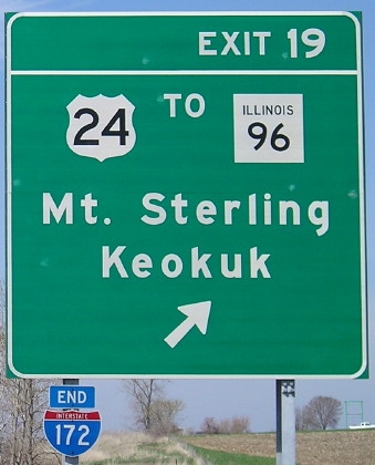
April 20, 2008: North end of I-172 in no place in particular, Illinois. Functionally, I-172 is a big bypass of Quincy and connection for Quincy to points southwest and southeast, but now it works for the northeast as well with progress on the IL 336 corridor. It’s part of the Chicago-Kansas City corridor, a name pushed as an attempt to get truck traffic to use I-88 to the Quad Cities and a series of four-lane  roads south of there to Hannibal, then US 36 (future I-72) and I-35 to KC. Illinois has also given the route a designation of IL 110, which like IA 27 is redundant for a good portion of the route.

So…why Keokuk? IL 96 goes to Hamilton, across the river from Keokuk, and IL 96 isn’t at this intersection — it’s to the west — so that’s three separate routes one must take from this location to get there. I won’t complain too much, though, since Missouri has the exact opposite problem of not mentioning Keokuk on US 61 until it absolutely has to!

Keokuk and Mount Sterling are the control cities for the entire length of I-172 except the south end itself. Compare, for example, this sign at an interchange with I-39. Mount Sterling is east on US 24.

(You thought I would go with the obvious choice for this number, didn’t you? Ha!)

Posted in Sequences | Comments Off on Photos by the numbers: 96
Feb 05

Texas Day 5A: Southwestward ho

Or: Two counties named Jim
Or: So that’s what 70 mph on a two-lane is like

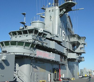
San Antonio (via Corpus Christi et al.), Texas, Jan. 27 — I started in the Corpus Christi area by driving back across the bay to the USS Lexington and spent two and a half hours there. The tours are all set up so there’s only one way to go.


Superstructure of the USS Lexington

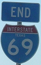
I-69 is signed on the BGSs, and some of those have “Texas” on the shields, but ground-mounted shields are inconsistent. There is a posted end where the freeway turns into a 35-mph curve. There is some beginnings of construction there, presumably to rectify that, but I-69 won’t be going south for a while.


This is wrong. So, so wrong. I-69 does not belong anywhere in Texas. Or Louisiana, Arkansas, or Mississippi.

Filled the tank and ate in Kingsville, near-last outpost of civilization on US 77 for a while. You can tell it counts for civilization in Texas because it has a Whataburger. Iowans only know Whataburger for its trolling of the (former) Big 12 North during basketball games, running advertisements during games like Iowa State-Kansas State when its northernmost locations are in Stillwater and Tulsa. Continue reading →

Posted in Trip Reports | Comments Off on Texas Day 5A: Southwestward ho
Feb 05

Photos by the numbers: 95

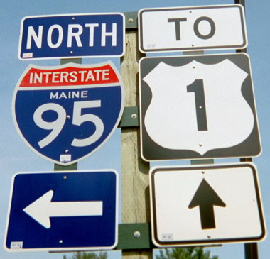
August 2002: Our vacation to Canada that year took us just inside the Maine border, to get that state checked off our lists.

Nevada, North Dakota, Maine. Quite a set, isn’t it?

Posted in Sequences | Comments Off on Photos by the numbers: 95
Feb 04

Texas Day 4: Remember the Alamo? They won’t let you forget it

Corpus Christi, Texas, Jan. 26 — Texans take an inordinate amount of pride in the shape of their state. It’s everywhere. (See, for example, the shield in the previous Texas post.) Today, that spirit manifested itself in the Texas-shaped waffles at the hotel breakfast.

I saw a pamphlet advertising an IMAX movie about the Alamo with 3 hours of validated parking. The movie was 45 minutes. It was entertaining, but I probably could have done without it, especially given a 15-minute History Channel version I saw later that did the same thing. I think it ends up a wash on parking though, and didn’t cost me any real time.

Since I was coming into the Alamo from the mall side, I completely missed the iconic structure at the beginning. Oops. Instead I started in the courtyard and wandered more or less in the reverse I should have. The interior is part shrine, part archaeological project, part museum. Incidentally, once you get past the arch that defines the front (that wasn’t there in 1836), the roof is a regular rounded concrete one.


Inside: Memorial to the Alamo fighters and views of the architecture

The parking garage’s pay setup gave me an hour more at $3, so I spent it wandering part of the Riverwalk. I ate pizza (Yeah, yeah, I know. But it was a place on the Riverwalk. That counts for something right?) and listened to a mariachi band playing for other customers.

Then it was out for a quick photo of the Alamodome, a detour back up to photograph the north end of I-37, then back south. Since it was early afternoon it was a good time to do the I-410 loop.
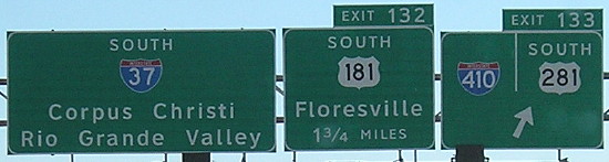
The south part of the loop was surprisingly empty and only four lanes. It got up there on the north side though, along with some fantastic interchanges. This is the first x10 that I’ve clinched. Not bad, considering that four years ago I-10 itself was my least traveled 2di.

While between I-35 and I-10 on the west side, I heard that the Texas Transportation Commission had just approved raising the speed limit to 75 on multiple interstates, including I-35 between SA and Laredo, practically all of I-37, I-10 northwest of SA, and I-10 between SA and Houston. I would soon find out why.

There’s not really much to see on I-37, even with my short detour to Wilson County. Parts of the asphalt rival I-80 in Dallas County as the “loudest” pavement I’ve been on. On the other hand, none of the roads in Texas have the pops and seams associated with freeze-and-bake cycles in the North.

I was surprised that I-37 only had “picnic areas” as opposed to full-fledged rest areas along the route. I did NOT see any state-name I-37 shields the entire time, a shame given that only Texas can lay claim to this number.

I approached Corpus Christi in the 5:00 hour, perfect for driving east. Saw the newly installed I-69 signs and downtown traffic wasn’t bad at all. Since I would be coming back this way, I thought I would take the road past the curve to become US 181 and see where it led me. I ended up on Shoreline Boulevard against the seawall. Although there are four intersections, the street’s name is “Interstate Highway 37” to the end.


A stoplight on an interstate? Not really, but doesn’t this look weird?

I took US 181 across Corpus Christi Bay, my first time on that route, and got a Days Inn in Portland. Temperatures were in the 70s, there wasn’t a cloud in the sky, and it was a perfect end to a fruitful day.

Posted in Trip Reports | Comments Off on Texas Day 4: Remember the Alamo? They won’t let you forget it
Feb 04

Photos by the numbers: 94

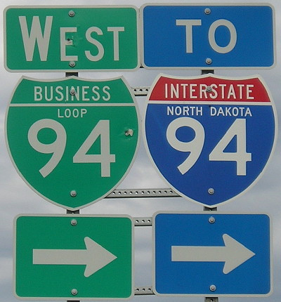
May 11, 2007: West of Mandan, North Dakota, a very long Business Loop 94 leaves old US 10 to return to the interstate. Just north of here is my westernmost point traveled on I-94, a segment that extends all the way to Ann Arbor. That’s about 70 percent of the route. It will be difficult to get to the rest.

Posted in Sequences | Comments Off on Photos by the numbers: 94
Feb 03

Texas Day 3: LBJ Day 2

San Antonio, Texas, Jan. 25 — It seemed obvious to do when I looked at it. There were two more sites related to President Johnson and the National Museum of the Pacific War in Fredericksburg, and there wasn’t that much driving in between. It turns out the AAA book grossly underestimates the time needed for all of them.

Route: US 290, US 87, I-10
Number of songs on my iPod with “Texas” in the name: Six, not including “Austin” or “Laredo”

An in-between designation of “four-lane undivided rural” for Texas highway maps would be a good idea. The only difference between 290 to Fredericksburg and some roads marked as two lanes is a narrow paved median.

The first stop was LBJ’s boyhood home in Johnson City. I skipped the films, having been at the museum the previous day. From the tour, I learned that his mom was college-educated, a rarity in those days, and the family would often talk politics in the kitchen.


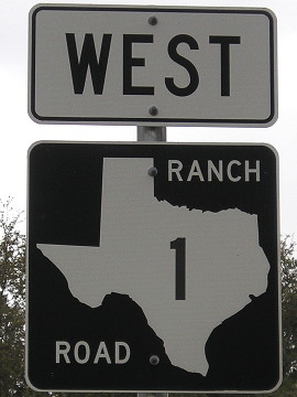
Old US 290 past the LBJ Ranch is Ranch Road 1

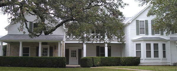
Stopped by the LBJ ranch and toured it and the Texas White House. I would’ve preferred to skip part of the driving — it’s not like I haven’t seen a Hereford before, even if these were shorthorns — but it was one way around. The CD from the Park Service could stand to be broken up into tracks, although it did track the driving pretty accurately.


Every room wired for phone lines, TV, and Muzak

The house wasn’t open until recently, after Lady Bird’s death, and it put the National Park Service in the interesting position of removing modernizations to bring rooms back to their bright-yellow formica 1960s glory. The bedrooms were just opened to the public a month ago. And wow, did LBJ love his telephones and electricity. Perhaps a byproduct of going without electricity early in life.

Reached the National Museum of the Pacific War in Fredericksburg at 3. AAA says you need two and a half hours, but four at a minimum is more like it. There’s an outdoor tour portion that is an hour alone, and I didn’t get through the entire museum before it closed at 5. Unfortunately, I was intent on meeting someone in San Antonio, and couldn’t take up the offer to use the admission the next day.

South of Fredericksburg, US 87 was my first experience of a 70-mph limit on a two-lane road, a curvy two-lane at that. I-10 starting at Comfort was very central Texas in character, but once I got nearer the San Antonio metro it escalated quickly. I had to pass my exit because of the traffic.

I had a reservation at a hotel in the northwest that used to be a Hampton but is now a Quality. I suspect that Hampton gave it up because of age. Upon my second trip to the room, I realized it had an ashtray and no “No smoking” marker outside. I went back to the desk for another room and got it. The new room…had an ashtray. I went back to find out what was up. He said the hotel was now smoke-free. When? December. I asked for a nonsmoking room that had already been one and got an upgrade to a “King Deluxe” with a fold-out couch and fridge.

Posted in Trip Reports | Comments Off on Texas Day 3: LBJ Day 2
Feb 03

Photos by the numbers: 93

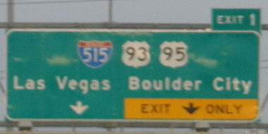
December 28, 2009: An unfocused view of I-515 from what is currently the end of I-215 in southeast Las Vegas. This was near the north end of my first travel on US 93, from Las Vegas to its south end in Wickenburg, Arizona. (I wasn’t driving, phew!) However, the Hoover Dam bypass opened after I was there, “de-clinching” the route for me in Arizona. I still have my clinch of I-515 though, my only such route in Nevada.

Posted in Sequences | Comments Off on Photos by the numbers: 93
Feb 02

Texas Day 2: LBJ and basketball

Austin, Texas, Jan. 24 — The first order of business on this gray day was to get an actual car. The Nissan Altima had less than 1000 miles on it and a “push-button” start.

I spent the short trip to the LBJ Museum getting used to the car and finding a fatal flaw in the GPS — it and frontage roads in Texas do not get along. It said “Keep right onto I-35 South” when I was supposed to take a right onto the I-35 frontage road NORTH a short distance before merging. This happened in both directions with the frontage roads, and would happen later as well.

It hadn’t started raining yet, but the clouds looked mean as I walked to Darrell K. Royal-Texas Memorial Stadium and found a huge addition to the north end zone that wasn’t there when I visited in 2005. It even has a food court. In its own way, it’s a physical manifestation of the expression “We’re Texas, and you’re not.”


What you don’t see: A giant inside view of the floors and floors of presidential documents. Plus, an animatronic re-creation of Lyndon himself.

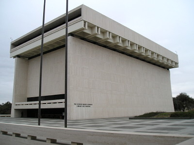
I spent the rest of the morning inside the Lyndon Baines Johnson Library and Museum. The outside is a stark light-colored building every inch its 1968 vintage. The inside was good and informative, encompassing LBJ’s whole life. The Oval Office replica and Lady Bird’s office are at the top. James Naismith’s original rules for “Basket Ball”, written up 120 years ago, were on display in a special exhibit.

I drove to Fran’s Hamburgers on Congress south of the Capitol after seeing it mentioned on a link someone sent me. It was good, but not $8.50 good.

Back north to the Texas State History Museum. Parking was $8. I decided that I would not be going anywhere in the time between museum close and the basketball game.

Photography was prohibited, which was a shame, because there was a lot of good stuff encompassing the entire history of Texas. The 20-minute film has a couple of surprises in it. I also watched the IMAX film “Tornado Alley,” which perhaps I shouldn’t have done because this was the same one in Iowa a while ago. I thought it was fine, and the closest I ever want to be to a tornado. I wrote this as I was sitting in an out-of-season overnight tornado watch, which is scary in its own way.

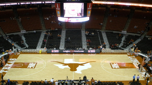
Two hours to kill. I walked to McDonald’s for some food, then the other way to the Erwin Center. I actually ran into some Iowa State fans! I got a cheap ticket and watched the crowd trickle in. It was just a trickle until right up to game time, and even then the arena may have ended up half full.


It turned out to be a good thing this game was on the Longhorn Network. You’d have better luck finding a Husker who didn’t hate Dan Beebe than a subscriber to LHN.


Cy gets chased by a herd of Longhorns at halftime.

Iowa State got off to a good start and then fell asleep. Royce White not only airballed two free throws and a three-pointer late in the second half, but the second free throw stopped close enough for him to catch it. It was a dreadful outing by both teams. There was no way this team could be competitive against Kansas or Kansas State. (Cue ominous foreshadowing gong.)

Posted in Trip Reports | Comments Off on Texas Day 2: LBJ and basketball
Feb 02

Photos by the numbers: 92

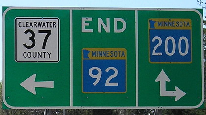
May 9, 2007: End of MN 92 southwest of Bemidji and the Headwaters of the Mississippi. Lots of forested area.

Like IA 92, MN 200 is part of a route that crosses multiple states with the same number.

Posted in Sequences | Comments Off on Photos by the numbers: 92