

September 7, 2006: Black Hawk Bridge in Lansing. The east end of IA 9, right by the south end of IA 26.
September 7, 2006: Black Hawk Bridge in Lansing. The east end of IA 9, right by the south end of IA 26.

July 17, 2007: Like there was any other location I’d pick for this one. West end of IA 8.

March 20, 2003: West side of Storm Lake, end of my first day of my first road trip. (The day before the 3/4 photo in Pocahontas.) North end of IA 110.
The 2009 and 2010 8-man champions lost in the semifinals to Fremont-Mills.
The district is already sharing every sport except football with North Sentral Kossuth, which itself is a shared pair at the moment. Football districts will be reorganized in 2012.
The technically-three school districts (A-R, NK, and Sentral) are still discussing arrangements for a triple-header merger, but it hasn’t been easy or simple, according to the Fairmont Sentinel. Regardless of the future, A-R still plans to close Ringsted Elementary.
“…We conclude that Elkhorn ceased to exist as a separate municipality on March 24, 2005…”
— City of Elkhorn v. City of Omaha, Nebraska Supreme Court, January 12, 2007

October 6, 2008: Western suburbs of Omaha. This photo was taken after Omaha forcibly annexed Elkhorn under Nebraska law that lets it do that. Elkhorn’s frantic rush to annex its own subdivisions to become too big to be eaten wasn’t frantic enough. In the meantime, dozens of subdivisions that were closer to Omaha remain rural.
While there is now a four-lane connecting Fremont and Omaha, that road changes designations in the middle. US 275 and US 6 both “exit from themselves” while supplemental road L28K handles the thru traffic.
I have been on US 6 in six states.

October 21, 2007: North end of IA 5.

March 21, 2003: Pocahontas, Pocahontas County. My first multi-day individual road trip.
I was hoping the bypass would open in the next couple of weeks so I could go to the ribbon-cutting. The bypass isn’t open yet, but the ribbon has already been cut.
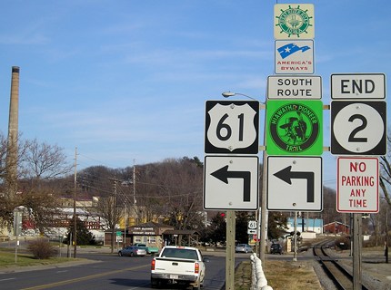
So I’ll need to go down there sometime to travel new 61 and refresh pictures like this one, at the end of IA 2. There will likely be a “Business” sign put above the 61 shield.
A decade ago, I took pictures from the front seat of the van on a couple of trips to Waterloo and Ames. Here’s one of them, taken months after IA 27 was first commissioned.

Although I used few or none of them, it was the beginning of a concentrated effort to document Iowa’s highways and what you see at their endpoints. (Yes, I know this is not an endpoint.) I started setting up the website a couple of weeks later and did a full launch in December.
Ten years and many pixels later — the above photo didn’t need to be shrunk — I alternate between my third and fourth digital cameras and have upgraded computers twice. (However, my newest photo editing software doesn’t seem to be as smooth when scaling pictures.)
As I tried to figure out the best way to mark the event, I also wondered if there was a way I could share some of the photos that otherwise would not appear on this site.
That gave me the idea to set up a new series of timed blog posts. Starting today, and continuing every 12 or 24 hours afterward, a new photo will appear. The photos won’t be random; they’ll be sequential. The first one will include a shield with the number 1, the second will include a shield with a number 2, and so on. Almost immediately, I realized I couldn’t limit the series to Iowa, since Iowa hasn’t had an IA 11 for 70 years, so the entire country is open.
I’m going to sort through my thousands of photos and find out just how far up I can go. I’ll also keep an eye on trying not to repeat dates or counties in the series until I have to.
This also happens to be my 100th blog post. I hadn’t planned on this many by now, but Texas A&M and Missouri “realigned” that expectation.
