Apr 28

Is CR’s Eighth Avenue bridge 82 years old, or 50?

Once again, the annual list of Iowa’s structurally deficient bridges includes Eighth Avenue over the Cedar River in Cedar Rapids. The list comes from the American Road & Transportation Builders Association, a “nonpartisan federation” promoting investment in infrastructure. It pegs the bridge date at 1938, but I’m not sure that tells the whole story.

The first bridge was built in 1938, or started at least. The Cedar Rapids Gazette reported on August 31, 1938, that George Koss Construction bid $167,777.77 to build the bridge. US 30 was rerouted onto it in 1940 and would use the bridge for 13 years.

However, the bridge got an overhaul in 1970. The Gazette said on September 30, 1969, that reconstruction “will include removal of the present 42-foot-wide bridge deck and the construction of a 52-foot deck plus two five-foot sidewalks.” On November 5, the Gazette reported the contract went to Cramer Bros. Construction for $639,050. This was more than expected, but inflation was high at the time. (Seven months earlier, when the public improvements commissioner thought it’d be $300,000, the main 1A story was President Nixon asking Congress “to retain the full 10 percent income tax surcharge through mid-1970.”)

Does that count as a new bridge? The piers are original, and the beams probably are too, so half-and-half at best. The deck and everything visible at street level is 1970, although that portion is showing its age as well and at some point every other streetlight pole got sawed off. Cedar Rapids has a target date of 2023 to replace the bridge, with integration into the flood control system, at a cost somewhere around $30 million. Before inflation, that is.

Posted in Construction | Comments Off on Is CR’s Eighth Avenue bridge 82 years old, or 50?
Apr 26

Some school timeline cleanup

Connections and corrections made recently on my school timeline page:

  • Burt and Sentral had a sharing agreement for five years (1988-93) before Burt went with Algona. Sentral had the high school and Burt grades 6-8. This is another case of short-term partnerships or attempts at partnerships that didn’t necessarily result in reorganization down the line.
  • That, however, led to a different mystery. References to Burt Elementary in the Algona Upper Des Moines abruptly end in mid-1998, and the city was renovating/demolishing the property before the consolidation was official. I think Burt was a zombie district — legally existing but all its students were going elsewhere — for a period of time.
  • In further reference to partnerships that didn’t happen, a tripleheader of Center Point, Shellsburg, and Urbana fell apart because Shellsburg refused to give up its kindergarten and first-grade students (Cedar Rapids Gazette, 11/11/88). The year before, Urbana only had nine eighth-graders (Gazette, 12/20/87).
  • Webster’s school closed in 1974 (Gazette, 6/9/74)
  • What Cheer’s school closed in 1979 (Gazette, 12/30/79). That fall, two seats on the Tri-County school board had zero candidates and had to be filled via write-ins (Gazette, 9/12/79). The original building was gone by May 1983 (aerial photos).
  • Plover’s school closed in 1980 (Laurens Sun, 1/24/80)
  • Ledyard’s school closed in 1981 (Algona Upper Des Moines, 2/12/81)
  • Pleasant Plain’s school closed in 1981 (Plainsman-Clarion, 2/19/81)
  • Marathon’s school closed in 1986 (Laurens Sun, 1/23/86)
  • Lakota’s school closed in 1997 (Algona Upper Des Moines, 8/16/01)
  • Quasqueton’s school closed in 2003 (Gazette, 12/22/03)
  • George and Little Rock began whole-grade sharing in 1989 (Lyon County Reporter, 11/27/91)
  • Wellsburg and Steamboat Rock actually talked about a merger in the early 1960s, while Steamboat Rock was fighting off Eldora’s intention to annex it. This “upset[] the Hardin County Board of Education’s own plan for school reorganization” (Grundy Register, 2/13/64) but the two ended up not even sharing students until two decades later. They started sharing some sports in 1983-84 (Grundy Register, 5/12/83).
  • Despite announcement of a NICL/Mid-Iowa conference merger on the front page of the 1/28/71 Grundy Register, it didn’t happen. The Mid-Iowa fractured in 1977 with its teams split between the NICL and Big Iowa. (I tend not to track conferences because they are very fluid, but in this case, North Tama may have helped precipitate the breakup by voting at the end of 1975 to leave the Mid-Iowa 18 months later.)
  • Conrad’s new building was dedicated March 11, 2001 (Grundy Register, 3/8/01)
  • Multiple previous schools for Vinton have been added (Cedar Valley Daily Times). The East school had time open in both the 19th and 21st centuries (1898-2002).
  • Fox Valley in 2002 is now accurately listed as last year for high school.
  • Cosgrove is now accurately listed as a building closure when Clear Creek and Amana began sharing in 1989.
  • I clarified that the Lowden closure in 1981 was a separate building (Gazette, 9/12/82) and retains an elementary. Lowden is part of North Cedar, a school district that formed in 1995. It almost began a few years earlier, but the Clarence-Lowden and Lincoln (Stanwood/Mechanicsville) districts stalled over whether Clarence or Stanwood would get the high school. It went to Stanwood for 20 years, and then in an extraordinary shuffle was relocated to Clarence.
Posted in Schools | Comments Off on Some school timeline cleanup
Apr 21

Mocking Iowa’s 2020s congressional districts (3)

After reading parts 1 and 2 of my attempts to create 2020s U.S. House districts for Iowa using 2019 population estimates, someone might ask:

These districts are too practical. Can you do something weird? Something that an unscrupulous non-Iowa legislature would try?

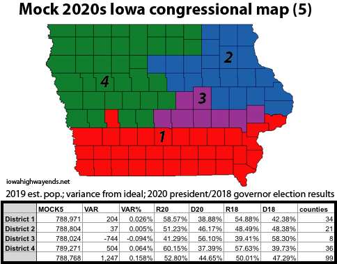
Mock 5: Let’s get weird within slightly adjusted operational parameters
District 1: Wow, that almost worked. Scott and Muscatine counties account for more than a quarter of the population. I don’t think the 2020 numbers would be enough to knock Audubon County out, but otherwise, this is … vaguely plausible? Have fun attending town hall meetings in both McCausland and McClelland, southern Iowa candidates.
District 2: Cerro Gordo County forms a sticking point in getting the western end figured out, but 2-county pairs marginally aid the perimeter rule. This is the most competitive of the four.
District 3: The goal here was to strip Polk and Johnson counties together. This would likely be the most racially diverse district in Iowa history — not just in those two population centers, but including Marshall County’s Hispanic population and the Meskwaki Settlement in Tama County.
District 4: Dallas County gets separated from Polk in a pretty standard northwest/north-central district. In such cases, though, consider that the Dallas County portion of West Des Moines will be one of the district’s largest cities and Waukee could crack the top 10.

Mock 6/5A: Keep the weird, tweak the edges
I have decided to exclude this map because, like Mock 2/1A, it didn’t  vary enough from the other. Besides, Mock 5 only got weird with one district, and …

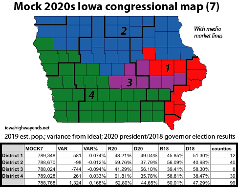
Mock 7: The name’s Mander. Jerry Mander.
District 1: It turns out one CAN get Waterloo, Cedar Rapids, and Davenport to share a district! Its county collection is only recently moderately competitive on the presidential level — these made for near-Democratic sweeps until 2016.
District 2: The last year Dubuque and Lyon counties shared a congressional district was 1862 — when much of north-central and western Iowa was still frontier. (The same goes, incidentally, for Black Hawk and Scott counties.)
District 3: Identical to Mock 5. Perhaps surprisingly, the overall variance is only slightly worse.
District 4: Maximum media markets: Ottumwa, Des Moines, Omaha, and Sioux City. (District 2 also has four.) Keokuk and Washington counties would see ads for every congressional race except theirs.

Posted in Maps | Comments Off on Mocking Iowa’s 2020s congressional districts (3)
Apr 20

Porker up

The principal at Duncombe Elementary in Fort Dodge (not Duncombe) kissed a pig to make good on a student fundraiser promise. It wasn’t a piglet, either.

Come for the fourth-grader’s shocked face, stay for the pigs doing…what pigs do. From the Fort Dodge Messenger.

(This needs to be an AP Exchange story. Also, imagine presidential candidates kissing 75-pound gilts and not itty bitty pretty pink piggies.)

Posted in Iowa Miscellaneous | Comments Off on Porker up
Apr 19

The (Volunteer) Corn State

IF
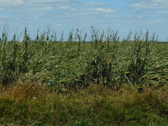
August 18, 2020: Flattened corn near Keystone, Benton County.

Last year’s derecho sowed the seeds of a weed that is Roundup Ready, extremely visible, and scattered across most of Iowa.

Volunteer corn is going to be all around this season, as unharvested corn takes root in what this year will usually be soybean fields. Iowa Public Radio has more. (There was a Spokesman article too, but that’s paywalled.) Kernels and ears left on thousands of acres will pop up without a care.

Control of volunteer corn requires a non-Roundup herbicide, as explained in this page from ISU Extension.

Posted in Uncategorized | Comments Off on The (Volunteer) Corn State
Apr 16

There’s a creek there?

From the DOT’s website:

The Iowa Department of Transportation is requesting public input for proposed improvements on Iowa 8 in Tama County.

OK, pertinent to my interests.

The proposed project includes the removal and replacement of an existing 12’ x 4’ box culvert under Iowa 8 at Rock Creek, 0.4 miles west of the west junction with Iowa 21 in Tama County.

The creek in question does not appear to be there in the real world; it looks much more like a waterway. This spot appears to be a branch of the water feature whose course starts to flow west of V Avenue, is channelized between there and IA 21, then flows northeast to eventually join the Cedar River east of La Porte City.

Anyway, the DOT is having the requisite public input period (PDF ad here) and it’ll happen next year. At least the project wasn’t going on when I was commuting last August.

Posted in Construction, Tama County | Comments Off on There’s a creek there?
Apr 14

US 20 concrete in Waterloo getting replaced

The Iowa DOT has announced that starting tomorrow, US 20 between the US 63 and IA 21 exits will move to head-to-head traffic to remove and replace the pavement in the eastbound lanes. (Is it Infrastructure Week here? — Ed.)

The press release states that this phase will last until July, and then I presume the same will happen to the westbound lanes. The first concrete here was laid in 1984, but not signed as part of 20 until 1986. I don’t know if there has been a complete replacement in between.

There will not be temporary connections from the ramps, judging by the release. Instead, all ramps on/off eastbound 20 will be closed at 63, 21, and Ansborough Avenue. Official detours will come later. I think that the best connection between 63 and the Crossroads Mall area would be to cut across D52 or D35 to 21. (To head to Dubuque, 21 to Shaulis Road — there’s a stoplight there now — to 218 near the casino.)

I think this project will preclude a photo refresh of those interchanges this year. I know the Waterloo area could use one.

Posted in Construction | Comments Off on US 20 concrete in Waterloo getting replaced
Apr 12

I-35 bridge project creates detours for US 30

Two years after a permanent change to the I-35/US 30 interchange in Ames, a temporary one is here, and this time it will affect some football gameday traffic.

Starting last week, the DOT closed some ramps at the interchange in a project scheduled to last the entire construction season (story: WHO). According to a PDF included in the story at WOI:

  • Eastbound 30 to northbound 35 will need to use Dayton Avenue and 13th Street.
  • Westbound 30 to southbound 35 will need to go to the Dayton exit and turn around.
  • Southbound 35 to eastbound 30 will need to go to the Dayton exit and turn around.

My thinking is, if you are trying to get to NB 35 after a game, go over to Grand Avenue or Duff Avenue and go north to 13th that way. The ramps at Dayton don’t have stoplights (unless they get temporary ones), and there are going to be a lot of lefts there.

Posted in Construction | Comments Off on I-35 bridge project creates detours for US 30
Apr 09

Iowa’s 1920 Highway System: The short and winding road


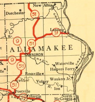
Iowa Highway Commission 1919 map. Notice the absence of a primary road southeast of Waukon and the town of “North McGregor,” which did not become Marquette until March 29, 1920.

IA 51 has never been outside of Allamakee County, but it has a history of intrigue.

Allamakee County, once ranked in a “national amenities index” as the best county in Iowa “from the standpoint of scenery and climate”, is in the heart of the Driftless Area, a section of the Midwest that nearly all the glaciers skipped over. The rolling hills, along with the Yellow and Upper Iowa Rivers, make for many scenic but winding roads.

The route shown above was the initial plan, but based on IHC minutes, appears to have been changed right as the 1920 system was going into effect. The southern portion connected the county’s two largest communities, Waukon and Postville, but the northern portion missed other towns. This proto-IA 51 did not directly connect to any route in Minnesota.

The south half is best described as IA 51, W4B (but not quite), W60, and A52 south of Waukon. Leaving Waukon, IA 9/51 had a big kink using Green Valley Road and A44, and then proto-51 split from 9 following X20. Near the Upper Iowa River, proto-51 turned north on gravel X6A. The 1914 bridge it used across the Upper Iowa River was, according to BridgeHunter, “technologically significant as one of the last of the pre-ISHC trusses in the state” and closed in 2007. Proto-51 used the rest of X6A and met present IA 76 less than two miles south of the Minnesota border.

The first plan to build a road in the Yellow River area (FAP 170) started in 1922, based on a separate plan for the half-mile of road south of Waukon (FAP 169). Although the new route of 51 is drawn on the 1922 map, when this road (W4B between IA 51 and just east of W60) was actually built is murky. There is an item in the Postville Herald on November 6, 1924, referring to “new No. 51 from Postville to Waukon”, but at the same time, “Graveling on No. 51 to start this week” came nearly two years later. To further complicate matters, 1912 and 1914 county maps do not show any road in Section 10 and part of present W4B never gets drawn in on the 1914 map.

The only way to continue east involved sections of what are now Smith Road, Livingood Springs Road and Bethel Road. East of that, there was a pre-existing road (although a bit closer to the river for about a mile in Section 1). While some 1920s state maps look like there was a line all the way to Red School Road, the 1926 project definitively followed present W4B and X16, joining present IA 76 southeast of Waukon.

In and just northwest of Waukon, the revised 51 followed a different route. North of the intersection with Mount Olivet Road, the original is close to but not always present IA 76. For maps of this, see the IA 51 (1920) page.

Notice that the 1919 map did not include a primary between McGregor and Waukon. That road was the last major addition to the system. It was proposed by the Allamakee and Clayton county supervisors in June 1920 and approved by the IHC July 8, handwritten into the minutes. That addition enabled the relocation of the southern half of IA 51.

A portion of this research comes from December 2019 at the State Historical Building. To my surprise and semi-consternation, I was told the only way to get my hands on the minutes was literally to get my hands on the minutes — combing through the original documents (!), tied shut since who-knows-when, three months at a time. Next time — if there can be a next time — I’ll be sure I have more than an afternoon.

Posted in 1920 Highway Sytem | Comments Off on Iowa’s 1920 Highway System: The short and winding road
Apr 07

Mocking Iowa’s 2020s congressional districts (2)

The Iowa State Fair does not have a redistricting contest. There are no awards for Most Politically Balanced, Fewest Counties, Best District Made With Bacon, etc. Nevertheless, I have a hankering to be the Robin Tarbell-Thomas of submissions.

In my first set of mock districts using 2019 population estimates, my Mock 2 was the third attempt; my second one had just fiddled on the edges of the first making it more of a Mock 1A.

Mock 3: Failure to launch

It is quite easy, or at least it’s seemed easy, to create a district of around 777,500 people plus or minus a thousand. Unfortunately, we’re looking for 788,768, and that last 11,000 or so is really hard to come by. Inevitably the next county to grab is thousands of people above or below that.

Then there’s the other end of the equation. You can get three districts that come in a few hundred under the ideal, and then No. 4 clocks in at 790,000-plus. I managed to make both of these mistakes, along with a third type: Within 200, but a state-border county was left unclicked.

There are certain county pairs that would juuuust about work on the edges, if only their populations switched. The most common cases I ran into were Cedar/Jones, Worth/Winnebago, Ringgold/Taylor, and to a lesser extent the Hardin/Franklin/Butler/Grundy square.

I did a little work thinking about a five-district map, which as I noted in my previous post has gotten much more difficult as Polk and Dallas counties explode in population while most of the rest of the state doesn’t. Polk’s increase alone since 2000 would account for 18% of a single district in a five-set. I would start with Polk-centered districts, but keep running into a block on the northern edge of the southeast district with Benton, Linn, Jones, and Clinton being just too big.

Mock 3 stands in for my busts.

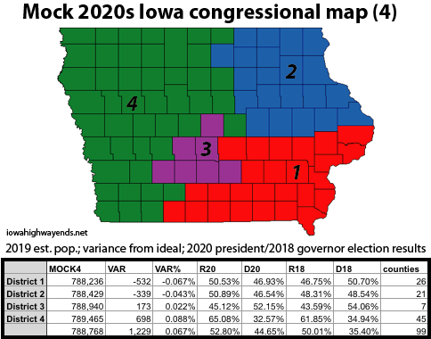
Mock 4: The Marshall County Dangler
District 1: A pretty competitive southeast quadrant resembling with only four counties different than that of the 2010s 2nd (Iowa, Poweshiek, Marion, Ringgold). This would be exceptionally ripe for a rematch of the 2020 2nd District race, and please don’t come after me if it happens.
District 2: Almost a perfect quadrant, and also extremely competitive, filling in a little from the 2010s 1st District and adding Cerro Gordo County.
District 3: I tried really hard to keep Polk and Dallas together, only to not quite get flush on the eastern border. We might be able to come back to this one after the 2020 estimates come out.
District 4: When the LSA creates maps and one county sticks out in some direction, it’s typically connected to the rest of its district by a full county width (see the 1990s map). This has a half-county connection, which doesn’t look great and adds to the perimeter. The most amusing far-down-the-list byproduct of this may be, like in the 2000s, a different congressperson for each of BCLUW’s school buildings.

Posted in Maps | Comments Off on Mocking Iowa’s 2020s congressional districts (2)