
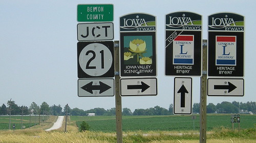
July 7, 2013: The Lincoln Highway meets IA 21 northwest of Belle Plaine. A loop follows the earliest route, while the main route follows 21. This was the east end of secret IA 940 (1980-2003).
With this winter being what it is, and gas prices being what they are, there aren’t going to be new pictures coming for a while. But what I can do is go through the pages and update them (in at least one case, updated after more than a decade) with new information or pictures that I didn’t have online before.
For this batch of updates, IA 940 (the tiny secret route near Belle Plaine) has four new pictures with the addition of photos from last year, the Lincoln Highway’s centennial. Here’s what’s been added elsewhere:
- IA 949 and 978: The 2002 Mills County map showing both routes
- IA 965: Re-creation of signs erected at the former US 6/218 intersection 45 years ago
- IA 941: Pictures from I-35, and larger versions of the pictures I had
- IA 931: LGS photographed after it snowed in May
- IA 927: Some updated information and photos from 2012 at the I-280 interchange
- IA 925: The third iteration of BGSs on I-80 in the 21st century