Oct 27

North Tama volleyball going to state

Again!

North Tama is making its fourth trip to the state volleyball tournament in six years. The Redhawks defeated Southeast Warren at Newton on Wednesday night in straight sets. (Story: Marshalltown Times-Republican)

North Tama will play AGWSR on November 1. Class 1A is played in three consecutive days. The championship games November 3 will be played in descending order of class, with Class 5A at 10 AM and Class 1A at 7 PM.

Also, there is no school tomorrow for North Tama because of state cross country, says the school’s Twitter account.

Posted in Sports, Tama County | Comments Off on North Tama volleyball going to state
Oct 26

A ‘reduced-conflict intersection’ by any other name

The Iowa DOT’s “Transportation Matters” blog has a post extolling the virtues of a new type of intersection southeast of Fort Dodge. It is a new type of intersection in Iowa, but it’s not the first time one like this has been attempted.

The opening of the “Marker 126” gas station is creating a traffic situation at US 20’s intersection with gravel Poplar Avenue. This is the first gas station to open on four-lane 20 in the entirety of Webster County. Here’s an April article from the Fort Dodge Messenger before its opening was pushed to last month. It’s unfortunate that it wasn’t built at the interchange just to the west, or even just on the other side of 20 where P6D serves as a frontage road for a short distance, but I’m sure there are reasons. (There are no plans to reset the mile markers on 20 across Iowa to match its present alignment, so the name is safe.)

In the “reduced-conflict intersection”, so named because there are fewer places for bad crashes or “conflict points”, cross traffic cannot go straight through or make a left at the intersection. Instead, traffic entering 20 must first go right to go left.

IT’S A REBRANDED J-TURN. This type of intersection was roundly rejected after being proposed nearly a decade ago at two much more prominent intersections, US 65/IA 117/IA 330 in Jasper County and US 30/218 in Benton County. One place it wasn’t rejected was the city of Wapello, which will get a J-turn at the south side of its US 61 bypass after fighting to get access there.

To the west, Sparky’s One Stop at US 20 and IA 4 is being rebuilt after it unfortunately lived up to its name last November.

Posted in Construction | Comments Off on A ‘reduced-conflict intersection’ by any other name
Oct 24

Congressional district table updated

The Legislative Services Agency’s second map of 2021 made things annoying when it came to numbers. The designation for the 1st and 2nd Congressional Districts flipped. There’s something about a rule of “easternmost.” Eyeballing the map, the geographic center of the southeastern district looks like it is farther east than the northeastern district, and the case was the reverse in the 2010s, and I think that’s the explanation. The 2020s map has been added to my historic congressional district map page, although I had to switch computers and for some reason I can’t get the colors to match exactly. I also added horizontal rules to better indicate which map goes to which decade, and extended the headline to 2032 since that’s how long the newest districts will last. (Technically, it’s Jan. 3, 2033, but let’s go with election years for now.)

More time-consuming was the table, as each county that was in the 1st but was now in the 2nd (and vice versa) couldn’t just have its color block extended, but required a new cell. The new table is here, updated after 11 years. Here is a breakdown of where counties went:

  • 16 counties stayed in the northeast district (1st to 2nd)
  • 16 counties stayed in the southeast district (2nd to 1st)
  • 13 counties stayed in the 3rd District
  • 33 counties stayed in the 4th District
  • 3 counties moved from the old 1st to the new 1st: Iowa, Jackson, and Jones.
  • 6 counties moved from the old 4th to the new 2nd: Butler, Cerro Gordo, Chickasaw, Floyd, Grundy, and Hardin. This is the first-ever split for Hardin and Franklin.
  • 8 counties moved from the old 2nd to the new 3rd: Appanoose, Clarke, Davis, Decatur, Lucas, Monroe, Wapello, and Wayne.
  • 3 counties moved from the old 3rd to the new 4th: Fremont, Mills, and Pottawattamie.
  • Marshall County moved from the old 1st to the new 4th.
  • Greene County moved from the old 4th to the new 3rd.
Posted in Iowa Miscellaneous, Maps | Comments Off on Congressional district table updated
Oct 21

A new name in the records

State football playoffs for the four smallest classes begin today. It seems wrong to me that they start so early, but that’s what happens when you have to wedge in an extra round but also only play one game a week but also still have to have the finals at the end of the week before Thanksgiving.

Somewhere in the mess of the IHSAA’s website is the football record book, which I will link directly here. This year’s book has something you don’t see everywhere:

Yes, that is a Katie in Iowa’s high school football record book, and Van Meter did score 11 touchdowns in a game last season. Last year, Lindsay became the first girl to score in a state football championship game — on not just an extra point but the game-deciding field goal — on Van Meter’s state championship run.

Lindsay, a junior, made a school visit to Iowa State recently (segment starts at about 56 minutes), and she said in the linked podcast she wants to play football in college. I hope someone told her Iowa State can use all the kickers it can get.

Posted in Sports | Comments Off on A new name in the records
Oct 18

NT volleyball begins quest for state

The high school volleyball postseason began Monday for the smaller classes. Six teams in Class 1A received byes, in alphabetical order: Ankeny Christian, Burlington Notre Dame, Don Bosco, Gladbrook-Reinbeck, North Tama, and Springville.

The cluster of four teams in a small area — especially NT and GR — has caused an interesting geographical bracket setup. GR is the southernmost team in a north regional. NT is the second-northeasternmost team in a regional half northeast of Des Moines and half encompassing all of south-central Iowa.

North Tama’s 33-4 record includes invitationals, including the Springville Invitational on Sept. 17, when the Redhawks lost their No. 1 ranking to the Orioles. Other teams played far fewer games; Orient-Macksburg is 1-15.

Only Southeast Warren is more than two games above .500 in the 15-team regional. It is possible SEW could play NT in the final at a site to be determined.

First, tonight North Tama plays 5-29 Collins-Maxwell in Traer.

If the Redhawks make it to state, they’ll be playing in Coralville, which stole the tournament from was awarded the tournament over Cedar Rapids, in an arena that refuses to disclose what Mediacom paid for naming rights. (As a Gazette employee and believer in the public’s right to know, this offends my sensibilities.) The “Fieldhouse” next door is in a $1.4 million, 10-year deal with GreenState Credit Union., only slightly less than what MidAmerican Energy paid to have its name and logo plastered on the turf at Jack Trice Stadium.

GO REDHAWKS!

(The Bound site does not appear to honor right-clicking for “open in new tab”. How rude.)

Posted in Sports, Tama County | Comments Off on NT volleyball begins quest for state
Oct 17

Huebinger’s Glidden map is wrong

Corrections are important, even if they come 110 years late. This one affects stuff I’ve written recently.

Huebinger’s Map and Guide for Iowa Official Trans-Continental Route, published in 1912, draws Glidden’s business district in the wrong place.

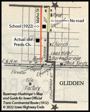
Huebinger puts the business district at the south end of Nevada Street, with a full extension to the north side of town, where US 30 is today. However, a 1906 county atlas and modern Google Street View show that neither are true.

The “bank” building marked in the map exists today, at the corner of Idaho and 1st streets. The Presbyterian Church is also a block west of where it’s marked. The school, built in 1921-22, did not need to take out a part of Nevada Street because that part of Nevada Street never existed. It’s marked as an “irregular survey” in the 1906 city map.

There are at least two cases where the route appears to have shifted between the time the guide was created and the time the Lincoln Highway took the route as its own, but this is the only outright, unexplainable map error that I’ve found.

So in Huebinger’s route, the Transcontinental should have gone down Idaho Street, then used two blocks of 1st Street before going south on Colorado Street. From what I can tell, Idaho continued southward to the next road at the time, instead of the Transcontinental needing to use Colorado, and the 2011 Heritage Byway reflects that.

Idaho Street’s time as part of the Lincoln Highway was limited. Two railroad crossings between Glidden and Ralston could be eliminated if an alternate route a mile north became official. The day before the Lincoln was dedicated, the Glidden Graphic newspaper warned against a change in the route. In early 1914, as Iowa State Highway Commission county maps were being finalized, the south route to Ralston was omitted completely. “We Lose the Highway,” the Graphic editorial headline said Feb. 12, acknowledging defeat but vowing to continue support for the road.

Gregory Franzwa wrote in his 1995 book on the highway in Iowa, “Strangely, old-timers insist that, this evidence notwithstanding, the Lincoln Highway did in fact come in from the south and pass through the business district.” He found correspondence in the national association’s archives showing multiple officials had the wrong impression about the road.

Either way, the south route is remembered today with the Heritage Byway Loop that goes through Glidden, east on 210th Street, and past the corner markers that George Gregory set up in March 1914. IA 6 and US 30 always skipped downtown Glidden.

Posted in 1920 Highway Sytem, Maps | Comments Off on Huebinger’s Glidden map is wrong
Oct 14

IA 17 construction prolonged

What was originally promised as a 15-month construction project appears to have been extended to two full construction seasons.

In March 2021, the closure of IA 17 east of Boone was announced. At the time, it was expected to be closed until July 2022. However, on the 511 site, there is still a closure there, with a completion date of November 23 (the day before Thanksgiving, the traditional end of construction season).

The detour route uses a newly constructed connector between IA 17 and the Lincoln Highway, so the work going on right now is on the bridge going over the Lincoln Highway and the railroad tracks. Regardless, the route for new 17 has not opened yet, and it could be another seven weeks.

Posted in Construction | Comments Off on IA 17 construction prolonged
Oct 12

Lincoln Way Burger King in Ames closed

Last week I drove on Lincoln Way through downtown Ames for the first time in a while. There have been changes since I was doing that regularly — though not nearly as many as US 65 through Bondurant — but one jumped out at me. The Burger King at 902 Lincoln Way has closed. The signage was gone and the menus at the drive-thru were punched out.

This is a very recent development, given that Google Street View was just through in August. I found an Ames Tribune article from May 2018 about the beginning of a rezoning project intended to completely reshape Lincoln Way into a “Downtown Gateway” and the BK was among “nonconforming businesses.” The Ames City Council that June approved the new zoning rules after excluding an area including the Culver’s, but the BK got no reprieve. It’s an eviction of sorts.

The Lincoln Way Burger King was the site of an armed robbery on March 30, 1989. A 5-foot-2 kitchen worker escaped through the drive-thru window and was able to contact police, the Tribune reported the next day. Two Iowa State athletes were arrested; one was later found not guilty. More about the robbery can be found here (the date given is incorrect).

The city of Ames’s official plan for Lincoln Way between Grand and Duff avenues includes a “road diet” proposal (eww) that “calls for the southern extension of Grand Avenue and the realignment of the US 69 designation.” A very new extension of Grand Avenue now cuts from the Hy-Vee through the golf course to South 16th Street, but it is two lanes, and having traffic for northbound 69 turn left at the intersection of South 16th and Duff Avenue — the first stoplight north of the US 30 exit — is not optimal from a traffic flow perspective.

Posted in Iowa Miscellaneous | Comments Off on Lincoln Way Burger King in Ames closed
Oct 10

Build for nine, stripe for four

An I-80 construction project in Cedar County is designed for the long-term future.

The Oct. 18 DOT letting includes both bridges over Sugar Creek. That’s between the IA 38 exits, by the rest areas. This is one of the two places in the state where one direction of interstate traffic is briefly unable to see the other, and the crossings aren’t exactly parallel. The westbound bridge is wider than the eastbound to allow an auxiliary lane for traffic merging from the rest area.

This plan comes close to matching a proposal at the northbound IA 38 exit, just to the west, which in 2018 included the ULTIMATE LANE. The width of these bridges, with four lanes of traffic in each direction, is the most notable part of them, but expansion of the interstate to six or eight lanes for any distance in this area is a long way off.

Posted in Construction | Comments Off on Build for nine, stripe for four
Oct 07

Meanwhile in Marietta

There is a tiny parcel of the Marshalltown school district, half a square mile, that isn’t directly connected to the rest of the district. It is connected via what, in the Iowa legislative redistricting process, is called “point contiguity” — that is, the parcels meet at a junction but do not have a land connection. That’s not allowed in either redistricting or school district boundary drawing.

How did it get there, then? It was grandfathered in from 1946.

The middle feature circled in blue is Marietta No. 4 school, one of thousands of such township schools once peppered methodically across the state. The school was discontinued in 1946, which was a formality, as the Times-Republican article about it reported it had not been active for a decade. The territory was divided between the Albion and Lamoille districts.

Lamoille later merged with State Center, and Albion merged with Marshalltown. The north half of the southwest quarter of Section 23 — the rectangle with “J.T. Packer” — went with Albion to Marshalltown, although it’s surrounded by State Center/West Marshall territory.

While looking in to that, I found out a few more things about the area that has changed in the past decade.

  • Marietta became a ghost town after losing the courthouse to Marshalltown in 1859. It never had the city grid seen in the 1885 plat book. There used to be a large wooden marker in a field, that I unfortunately never got a picture of before it vanished. The only trace is on Google Street View from 2009, where we can see “Marietta, Iowa / First / Marshall County / Court House / [illegible]”. Note the land owned by Robert M. Timmons just to the north, namesake of Timmons Grove county park and campground.
  • The Hartland Friends Church, the western circled site, was demolished in the 2013-14 school year, according to aerial photos. The Hixsite church, the eastern site, was demolished just last year, between August and November (aerial photos/Google Street View). Quakers are a part of Iowa history — Herbert Hoover was born a Quaker, and there’s William Penn University in Oskaloosa — and Marshall County “became the largest center of Norwegian Quakerism in the United States.”
  • Albion, just north of Marietta, has renamed its annual festival the Rail-Trail Festival, after its previous name was related to the school building demolished in 2018. The “rail” is the Iowa River Railroad, which abandoned nearly its entire trackline in 2012 except for the segment between Ackley and an ethanol plant near US 20. The “trail” is the hope of converting the right-of-way into a bike path. IA 330 had an overpass above the railroad until 2002, when it was replaced with an at-grade crossing, and those gates have been removed.
  • The IA 330 at-grade RRX just north of the E41/S75 junction, which in my experience has been awful for decades, finally got replaced last year!
Posted in Iowa Miscellaneous | Comments Off on Meanwhile in Marietta