Jul 10

Texas’ ISU license plate mentioned in Supreme Court case

(No, not that one. Or that one, either.)

In a 5-4 U.S. Supreme Court ruling that Texas has the right to deny Sons of Confederate Veterans a specialty license plate, Justice Samuel Alito dissented by way of a sports analogy:

If you did your viewing at the start of the college football season and you saw Texas plates with the names of the University of Texas’s out-of-state competitors in upcoming games — Notre Dame, Oklahoma State, the University of Oklahoma, Kansas State, Iowa State — would you assume that the State of Texas was officially (and perhaps treasonously) rooting for the Longhorns’ opponents? [dissent p.2]

(Look at the company we’re keeping!)

…And if Texas really wants to speak out in support of, say, Iowa State University (but not the University of Iowa) or “Young Lawyers” (but not old ones), why must it be paid to say things that it really wants to say? [dissent p.14]

If there’s a Dallas-Fort Worth I-Club, there’s your cue.

Alito must have had an up-to-date list, because it was only about 15 months ago that the Texas DMV approved the ISU design in the first place.

[h/t Ann Althouse, who did all the heavy lifting here]
Posted in License Plates | Comments Off on Texas’ ISU license plate mentioned in Supreme Court case
Jul 09

Dows depot still open, just not as welcome center

A month ago I mentioned the new Iowa highway map did not include the Dows welcome center, further confirmed by the removal of signs for it on I-35. Austin Draude of KLMJ Radio in Hampton let me know that while the Dows Depot’s welcome center status has been revoked, it is still open. Reprinted below, with his permission, is the news story the station ran.

Those traveling near Dows may notice the Iowa Welcome Center signs are gone. That’s because the Dows Depot is no longer an official Iowa Welcome Center. Mary Ellen Patterson is the director of the Depot and told KLMJ news that lack of funding has hurt the Depot.

After being closed during the winter, the Depot reopened in April. Patterson says the loss of advertising on the interstate has led to the loss of visitors to the Depot.

The Depot is still home to various historical items, maps and various items to purchase. While there is no attendant in the building, Patterson says anyone wanting to purchase items may do so by going to the mercantile in Dows.

Posted in Maps | Comments Off on Dows depot still open, just not as welcome center
Jul 08

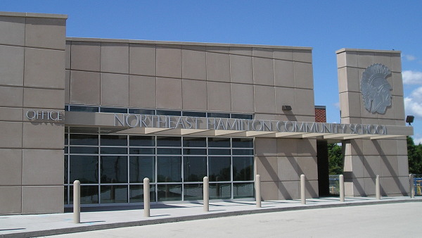
The last outs for Northeast Hamilton


May 28, 2012: Northeast Hamilton completed a major construction project at the beginning of the decade.

The final event for Northeast Hamilton High School in Blairsburg will be a baseball game against North Tama tonight. The regular season ends Friday at Don Bosco.

The Trojans will play CAL at Belmond on Tuesday in the first round of district baseball.

Next year, NEH will become K-6 and send grades 7-12 to Webster City.

UPDATE: North Tama 17, Northeast Hamilton 1.

Posted in Schools | Comments Off on The last outs for Northeast Hamilton
Jul 07

So early it’s almost late

The Hallmark Channel has decided “You know what, they say we’re the Christmas movie station, let’s go with it in every way possible.”

HallmarkJulyXmas

The premiere. Of a Christmas movie. A week after Independence Day — or six days after also showing “Home Alone.” (Warning: autoplay video and potential nausea/shock of introducing a week of Christmas movies in July.)

(Yes, I was watching Hallmark Channel. It’s not my fault the only good thing on TV right now is reruns of “The Golden Girls.”)

Posted in Uncategorized | Comments Off on So early it’s almost late
Jul 03

Gladbrook residents submit petition for dissolution of district

WAIT WHAT

When a town loses its only school, it hurts. It really hurts. The school district has exhausted its options, and the residents must move on with the new reality as best they can.

Except, in this month-old article from the Northern Sun-Print, in the wake of the closure of the Gladbrook school building, Gladbrook residents have decided to play a game of Global School District Thermonuclear War and submitted a petition to dissolve Gladbrook-Reinbeck entirely. This is unprecedented.** This isn’t cutting off one’s nose to spite one’s face; this is amputating at the neck. The closest case of a full K-12 district voluntarily dissolving in the modern era* is Boone Valley of Renwick, which was K-6 for one year as residents were deeply divided on whether Humboldt, Clarion, or another district was the best solution. Gladbrook-Reinbeck, you do not want to be the second coming of Boone Valley.

The petition committee already knows what it wants to do: Attach the old Gladbrook district to Green Mountain-Garwin (!!!) and the old Reinbeck district to Grundy Center, with no further nuance. So North Tama/BCLUW/Hudson could get bupkis while GMG, which has made a living from scratch-off tickets (Marshalltown open enrollment) the past 25 years, could have a winning Powerball ticket dropped in its mailbox.

But would it bring the Gladbrook school back? At best, the answer is “Reply hazy, try again.” The Green Mountain elementary was built in 2002 and district enrollment is down 25% since then. Garwin just put on a wing and second gym thanks to PPEL money and a sizable school surtax — GMG’s rate is 11% while GR’s is 3%, by far the lowest in Tama or Grundy counties. But an influx of, say, 200 students into GMG (GR certified enrollment in Tama County in 2013-14 was 251.1) could allow Gladbrook to hold a few grades. This petition threatens to create long-lasting town-vs.-town resentment over a could. (Plus, has GMG been asked about this? I do not know.)

You only have to look 20 miles and 30 years away — or 20 miles and 10 years away — to understand there is no recourse on a closure. The Iowa Supreme Court, in Keeler v. Iowa State Board of Public Instruction (1983), said that as long as the school board has followed correct procedure and votes to close a building, the effect on a town is subordinate to consideration of the health of the district. In that case, Marshalltown closed the Albion school. The procedure refers to having scheduled, open meetings and “sufficient research, study, and planning,” established by the state in In Re Norman Barker (1977) and reprinted in In Re Closing Montour Elementary Building (2002). No recourse … within a district, anyway.

Should the petition to dissolve Gladbrook-Reinbeck gain any traction, we could see a whole new front open in Iowa’s small-school scramble. As the queen of relationship songs says, Band-Aids don’t fix bullet holes.

* Corwith-Wesley was in whole-grade sharing (thus not an independent K-12 district), Russell was forcibly shut down, and all others were K-6 or K-8 at time of dissolution, including East Monona in 2004.

** UPDATE 7/23/21: At the time this was written, I believed this was the only case of a town using the dissolution process to retaliate for closure of its school. It turns out Central Lyon’s decision to close the Doon school in 1985 also generated a petition, but the process stopped there. (Also, all my links to Traer, Dysart, Gladbrook, and Reinbeck newspapers got 404’d following consolidation. Bleah.)

Posted in Schools, Tama County | Comments Off on Gladbrook residents submit petition for dissolution of district
Jul 02

A drive through the Bohemian Alps

A trucker has put up his video log of US 30 from near Vining (but he pronounces it “Vinning”) to west of Tama on YouTube. About halfway through the segment he passes the 30/E66 junction (the split with the Lincoln Highway).

Posted in Tama County | Comments Off on A drive through the Bohemian Alps
Jul 01

New Iowa Sportsman’s Atlas out

A blurb in the Dickinson County News notes the Iowa Sportsman’s Atlas has been updated for the first time in seven years. What does this have to do with Iowa highways? The atlas uses Iowa DOT county maps as the base for its display of state parks, recreation areas, and other locations of interest for those who enjoy the outdoors. In that respect, what you’re getting is a big spiral-bound* — and now full-color — Iowa county map book. The website to order the atlas has a preview showing the top tier of counties.

*At least, it’s been spiral-bound in the past, which is immensely helpful if you want to have it left open to a page.

Posted in Maps | Comments Off on New Iowa Sportsman’s Atlas out
Jun 30

One year ago today

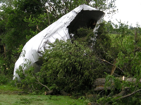
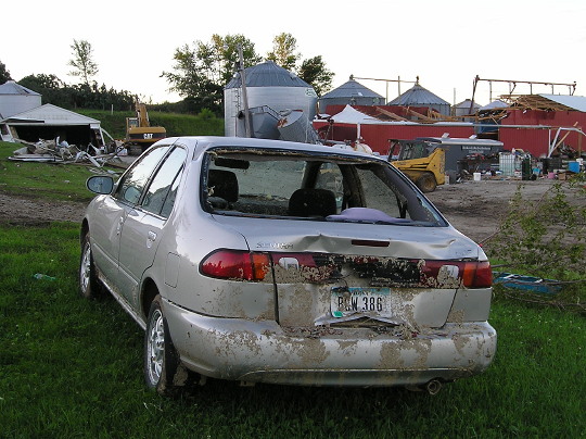
An EF2 tornado hit Traer during Monday’s storm, a deadly system that lashed Northeast Iowa with vicious winds and torrential rain. — Waterloo Courier, July 1, 2014

In all, the “One-two Punch” derechos of June 30, 2014 produced more than 300 non-duplicate reports of severe weather from eastern Nebraska to southern Michigan and northwest Ohio, including nearly two-dozen short-lived tornadoes (path lengths less than ten miles and durations less than ten minutes). The first derecho tracked from central Iowa to Lake Michigan (a distance of 320 miles) in five hours, with an average forward speed of 64 mph. — NWS Storm Prediction Center: Midwest Derechos of June 30-July 1, 2014


June 30, 2014, 2:09 PM. Screen capture from KCCI, which was clearly waffling about whether this was “in the viewing area” but stuck with it.


Photo taken July 2


Photo taken July 2


Photo taken July 2


Toledo Street and Westview Street, Traer. Photo taken July 2


Photo taken July 3

Posted in Tama County | Comments Off on One year ago today
Jun 29

Missouri trip Day 6

Route for June 27, 2014: Metcalf Avenue, US 69, K-68 becoming MO 2, I-49, US 71, I-29, I-35, MO 1, MO 152, I-29, MO 92, MO 92 Spur, MO 273, MO 371, US 36, K-7, connector to Rulo, US 159, US 59, I-29, US 59, US 71, MO 48, Route Z, US 69, Route C, I-35, IA 5, US 69.


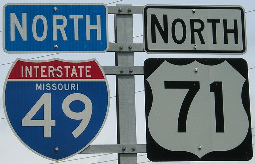
A VERY small number of I-49 shields with the Missouri name exist, which is a bad omen for those of us who like state names on interstate shields. The location of this sign shall remain hidden for its own protection.

To start my return to Des Moines, I drove south, then east, then north, to get the part of I-49 that I missed yesterday. I continued on that part of US 71 into downtown that is not a freeway. The MO 1 bridge was closed, so I did the part north of I-35.

I figured I would stop at McDonald’s in Platte City when I got there to check the weather, and it was a good a time as any to eat. I then took MO 371, old US 71, to St. Joseph. It wouldn’t serve to be a US route today.

It still wasn’t raining at St Joe, although it was cloudy, and I went to the second town in Kansas to use the library’s wifi from the car. (It worked.) The rain was almost all gone, so I headed west. (Also, the Pizza Hut on the edge of town recently closed.) Iowa Point is nothing but an intersection. White Cloud had an Lewis and Clark marker and was right by a bulging Missouri River. (Later in the day, I read I drove past the Four State Lookout. There were no signs. D’OH.)

Rulo, the southeasternmost city in Nebraska, got its one-block main street paved along with the new US 159 bridge. The GPS gave me 200 miles to go by sending me down I-29 and then on something unorthodox I wouldn’t have/didn’t come up with (top), but it seemed worth a shot.

The southeastern (road) corner of Nebraska. The true KS-MO-NE triple point is, of course, in the Missouri River about a mile to the east. The nearest anything is the Iowa Tribe casino to the southwest.

I followed that backroad path through northwest Missouri, and then had an uneventful trip back up I-35.

Posted in Trip Reports | Comments Off on Missouri trip Day 6
Jun 26

Missouri trip Day 5

Overland Park, Kansas, June 26, 2014 — I said “quarter after nine” for a wake-up call. It rang at 7:15 and 7:20. It wasn’t a good start to the day.

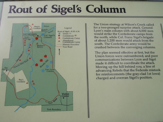
About an hour and a half up US 160, I got to Wilson’s Creek Battlefield National Historic Site. This is where Nathaniel Lyon, namesake of Iowa’s Lyon County, was killed after surprising the rebels early. However, Union could not hold it together and a Confederate regiment was mistaken for an Iowa regiment (wearing gray) until it was too late.

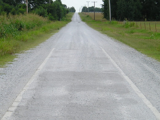
After two hours-plus there, I headed east to clinch US 60 in Missouri. Then, once into Oklahoma, I explored more of old US 66. The 1922 “Sidewalk Highway” on E200th and S520th is some of the worst washboard road I’ve ever encountered. So much gravel is on it the pavement is nearly gone. There was a Will Rogers Highway marker at the intersection of 220th and 520th, south of the 59/60/69 junction.


South end of a segment of narrow US 66 concrete in far northeastern Oklahoma. The concrete isn’t nearly as visible elsewhere — it’s more felt than seen.

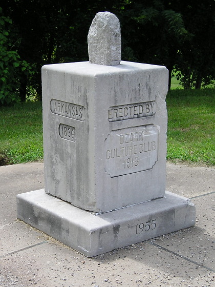
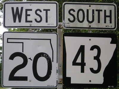
I returned to the very southwestern corner of Missouri to see the tri-state marker there. South of that intersection is one of the most interesting highway duplexes in the country, AR 43 and OK 20. From there it was time to travel the newly signed I-49 through Missouri. Right now, I-49 randomly starts/stops 5 miles north of the state line, and will for the foreseeable future because of lack of funding to bypass Bella Vista, Arkansas.


Tri-state marker at Southwest City, Missouri. Camera is in Arkansas looking toward Oklahoma. Below, the dual-state sign-duplex.

I thought I was going to end the day in Harrisonville, but there was no lodging available. There wasn’t any in Lee’s Summit either. After a call to the Super 8 line and an exchange with someone unfamiliar with the area, I used the last in both my physical and metaphorical gas tanks to take I-470 and I-435 into my fourth state of the day and plop into bed.

Posted in Trip Reports | Comments Off on Missouri trip Day 5