Feb 18

Iowa hospitality for the Sooners

Maddie Manning, the Ankeny player who stiffed Iowa State to play basketball for Oklahoma, had one thing she could still bring to the table even after tearing both ACLs in two years: Her family goes all-out to treat the OU women’s team to a big Iowa meal. It’s the biggest salad bowl you’ll ever see, and just listen to the rave review about the sweet corn.

The Cyclones were only slightly less generous Tuesday night, sacrificing a double-digit lead in the second half only to fight back and then win in overtime. (It’s the least we can do after gift-wrapping those wins in football and men’s basketball in Norman.)

If the embedded video doesn’t work, the link is here.

Posted in Sports | Comments Off on Iowa hospitality for the Sooners
Feb 17

New area code for eastern Nebraska

Nebraska went 60 years with two area codes, but years after an assignment frenzy in other states, three new digits are coming to the eastern part of the state: 531. That includes the entire part of the state bordering Iowa.

Unlike the splits in Iowa, 531 is an overlay of 402, meaning that no current phone numbers will change, and the entire area has to do 10-digit dialing for everything. I think splits are the better way to go, but I can imagine the overlay was preferable to a Lincoln-Omaha fight over who got to keep the old digits.

Posted in Maps | Comments Off on New area code for eastern Nebraska
Feb 16

KIMT cuts weather map area in half

After I wrote last week about KWWL eliminating some counties on its weather map, Austin Draude e-mailed to say that KIMT has done the same thing. The reduction in the Mason City CBS affiliate’s area sometime late last year*, though, is more drastic.

KIMT previously covered a 23-county area (and for a time, 24) in Iowa and Minnesota, as still seen on this image, from Algona to Decorah. But if you watch an online weather-cast today**, it’s down to the 12 counties of the official Mason City-Rochester Nielsen DMA, which is just outside the national top 150 markets. The only difference between it and KAAL now is the latter keeps Steele County MN (Owatonna), although I bet both signals are still accessible over the air there.

At last check, KTTC, the area’s NBC station, has more of Iowa covered despite being farther north and east (and based in Minnesota). But the periphery of the former area, including Franklin and Kossuth counties, loses the double (or triple) coverage it once had from some stations.

*Looks like sometime between Oct. 22 and Nov. 11; pay attention to the shaded counties in the latter although an outline has the old map.

**The weblink is dated to May 12, 2014, but apparently is updated every day. This tweet (with a dead link) indicates the station did a graphics update in July 2009.

Posted in Maps | Comments Off on KIMT cuts weather map area in half
Feb 13

IA 3’s last blocks change in Dubuque


April 18, 2006: This part of 9th Street in Dubuque is now two-way.

Remember this story from a while back about Dubuque getting rid of some one-way streets? That happened Aug. 25.

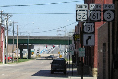
That conversion of east-west streets affected US 52 and IA 3 from the one-way pair of Central and White streets to the US 61/151 freeway. Now IA 3’s east end and west beginning are both on 9th Street — with a catch. The freeway ramps don’t change, reflecting the old one-way pair with the southbound exit/northbound entrance at 11th Street and the northbound exit/southbound entrance at 9th Street. A transfer of jurisdiction with Dubuque was passed earlier this week, but because of the split locations of the ramps, the state is turning over only one lane (the new eastbound lane) of 11th Street between White and US 61, and only one lane of 9th (the new westbound lane) between White and Central. The state will take over both lanes of the two blocks of White between 9th and 11th.

In the end, this will be a temporary change for both routes. The entire city-street portion of US 52 in Dubuque will be turned over to the city, and IA 3 truncated to around the IA 32/former IA 386 junction, when the Southwest Arterial is completed.

Lane miles are very important measurements, and the very refined nature of this transaction shows that, however weird it may be. (Just another reason to get rid of one-way streets!)

Posted in Highway Miscellaneous | Comments Off on IA 3’s last blocks change in Dubuque
Feb 12

What did Iowa do to you, “Agent Carter”?

Previously in Marvel’s “Agent Carter,” we had a 30-second scene where Peggy Carter met Dorothy Underwood from Iowa, who came to New York City to be a professional dancer.

Now we know her name isn’t Dorothy Underwood, and she isn’t from Iowa. She is, in fact, a Russian trained from a young age to be a ruthless spy/assassin in the Black Widow program (cf. Scarlett Johansson’s character in “The Avengers”). Perhaps we should be glad the writers didn’t name-drop a town in this case, although there is an Underwood, Iowa…

Between that, an ex-agent of SHIELD who was killed before the first commercial break, and a “valedictorian in Iowa City” targeted by HYDRA, the Hawkeye State isn’t doing too well in the Marvel Cinematic Universe.

In the comics at least, the character Hawkeye is from Waverly, but that has not been established in the MCU. And then somehow Clutier (!!!) got dropped into the comics as a town full of Nazi sympathizers (!!!). I was going to say the title of this blog post was tongue in cheek but now I’m not so sure!

Posted in Iowa Miscellaneous | Comments Off on What did Iowa do to you, “Agent Carter”?
Feb 11

Hamburg agrees to Nishnabotna grade split

The continuing cohabitational saga of the Farragut and Hamburg school districts had a partial resolution last week, as the Hamburg school board agreed to Farragut’s proposal of having the junior high in Farragut and keeping kindergarten through sixth grades in Hamburg. (The former high school building in Hamburg closes no matter what.) Interestingly, that special-session vote was 2-1 in a five-member board, qualifying for a quorum but not a majority approval. Compare the KMA story from earlier in the week when the decision was still up in the air.

As both stories note, an agreement on who goes where does not guarantee a future existence of the Nishnabotna school district. Both still have visits from the state School Budget Review Committee ahead.

Posted in Schools | Comments Off on Hamburg agrees to Nishnabotna grade split
Feb 10

Gladbrook school in danger of closing

Gladbrook-Reinbeck is considering reducing its school facilities, and closing the K-8 building in Gladbrook is one option, reports the Waterloo Courier. The others involve rearranging grades between the two towns but all put all of a grade’s students in one place.

With just under 600 students this year, G-R is about the median-sized district in the state — but that’s 100 fewer than in 2008, and 250 fewer than in 2000. Gladbrook’s foray above the 1000-population threshold ended before the 2010 census.

A school closure would be the first in Tama County since South Tama brought elementary classes to a new building southwest of the high school in 2006 and closed Chelsea in 2008.

My guess is the football field would remain on the northwest side of Gladbrook, by the Tama County Fairgrounds, since new locker rooms were built there recently.

Even closer to home, North Tama Superintendent Bob Cue wrote a guest column for the Cedar Rapids Gazette and a letter to The Des Moines Register about school funding. How G-R goes about dealing with its financial and enrollment shortfalls could have an effect on North Tama, which shares a long border.

Posted in Schools, Tama County | Comments Off on Gladbrook school in danger of closing
Feb 09

KWWL drops counties from weather map

In the first week of February, maps shown on KWWL during the weather portion of the newscast looked different. The map, which is still squashed vertically*, now only displays 21 counties.

Howard, Floyd, Franklin, Jackson, and Mitchell counties are gone, in addition to Crawford and Grant in Wisconsin and Jo Daviess in Illinois. However, Charles City and Prairie du Chien are still included in the map for forecast highs/lows.

Also during the first week of February, a tweet from Weather Services International said, “We are pleased to announce @KWWL in Waterloo, IA debuted #Max this week!” Compare the map in that tweet with Mark Schnackenberg’s Jan. 31 blog post. WSI is a subsidiary of the Weather Channel. Perhaps the two events are connected.

If this is a permanent change, KWWL has now shrunk to the bare minimum of the Eastern Iowa DMA, and Franklin County loses its place as a hub of Iowa television stations. As you can see on my Iowa TV maps and table (shameless plugs!), all of the counties dropped from the KWWL map are on at least one other TV station’s map (but does Charles City really prefer KTTC?).

So far, this is just for the daily newscasts; whether this also applies to severe weather coverage has yet to be seen. Schools in those counties still probably will send information in to the station. (For the record, the Super Bowl was unobstructed by a closings/cancellations scroll.)

*The map makes Tama County a square. Tama County is not a square. It’s not like there isn’t room for correct proportions!

Posted in Maps | Comments Off on KWWL drops counties from weather map
Feb 08

License Plate Letters — DBB

The question has been answered: Iowa will not be skipping “D” in the first position of the alphabetical side of the new cycle of license plates.

Posted in License Plates | Comments Off on License Plate Letters — DBB
Feb 06

A History of Concrete Paving in Iowa


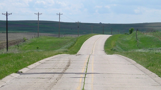
June 4, 2014: This concrete on old US 20 east of Cushing is from 1932. Old 20 west of Cushing to Sioux City was paved by 1924.

If that headline has you clicking for more, you’ve come to the right place, or at least the link to the right place.

A presentation at the 2013 Iowa Better Concrete Conference (second only to the Blue Ribbon Bacon Festival in ticket demand, one must presume) delved into Iowa’s “rich history of concrete paving.” Included in the history is construction on Correctionville Road in the 1920s that predates designation of the route as US 20.

The 2013 presentation is by the same DOT engineer, Todd Hanson, who created a 2009 report marking a century of concrete use in Iowa. According to those, the oldest still used today is Eddyville Cemetery Road — this now-dead-end stub right beside new US 63. Both reports mention a segment of “Moscow Road” being the second-oldest in current use, but this is NOT County Road X54 (which has that for its E911 name). The road being referred to runs west of the unincorporated town of Moscow, named River Street locally and 112th Street in the county system. It was part of the River-to-River Road in 1910, which later became US 32, and was bypassed in 1930. (The Muscatine County engineer helped me clear this up.)

There’s a reason Iowa’s association with concrete is so deep. From Discovering Iowa’s Historic Transportation Milestones (1999) (PDF):

Iowa’s first paving job using asphalt concrete was completed in 1928. The contractor required that a “royalty” fee be paid on the project. Fred White, chief engineer for the Highway Commission at that time, said the payment of royalty fees by the highway department would never happen again. Thus, it wasn’t until the 1950s that asphalt concrete was again considered for use on primary roads through the regular state construction lettings.

Posted in Construction, Iowa Miscellaneous | Comments Off on A History of Concrete Paving in Iowa