Oct 08

945 (probably for sure this time)

Millville, the ninth-smallest town in Iowa in 2010, has lost a third of its population of 30 since the census. It’s going to disincorporate, following Mount Sterling, formerly the 14th-smallest town in Iowa. Searsboro tried but the state wouldn’t allow it.

It only has a few streets (PDF), and Main Street consists of disjointed sections of old US 52.

Should the process be finalized, Iowa will be left with 945 incorporated places.

Posted in Iowa Miscellaneous | Comments Off on 945 (probably for sure this time)
Oct 04

First time for everything

Gladbrook-Reinbeck 35, North Tama 7. I wonder how many times G-R players were reminded this week that the Rebels had never beaten the Redhawks.

Posted in Sports | Comments Off on First time for everything
Oct 04

Upper Midwest Trip Day 7

The day started out with a bit of a letdown — since US 63 has not been signed around Rochester on US 52 yet, I’d have to come back at some point. Otherwise, though, it was a very scenic day on both sides of the Great River Road and then back into Iowa.

Route: US 63, Route VV, WI 35, US 10, US 61, MN 316 and back, US 61, MN 43 to WI 54 to Route M and back, MN 43, I-90, US 63, IA 9 to V18 and back, US 63, C66, V25, Airline Hwy, US 218, IA 58, Viking Road, Hudson Road, IA 58, US 63

My last remaining, drivable gap on 63 this trip was between Lake City and Red Wing. I stopped at Frontenac Golf Resort, which I wrote about in a separate blog post.

When I got to Red Wing, I had clinched US 63 in Minnesota (as signed in July), and now it was time to close a gap on US 61. First, I crossed into Wisconsin again. WI 35, the Great River Road in Wisconsin, was a very pleasant drive. There was a visitors center in Prescott related to the Great River Road.

The US 61 bridge over the Mississippi River is in the midst of being replaced, so I averted that potential de-clinched area. I even had time to double back and drive all of MN 316.
OLYMPUS DIGITAL CAMERA
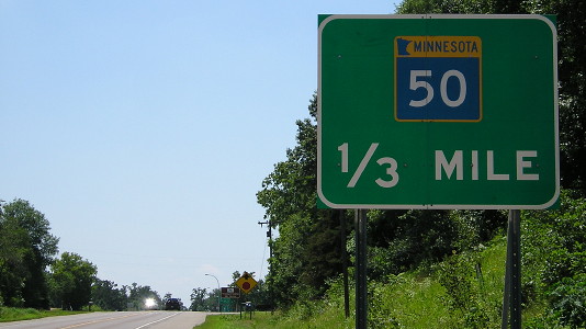
Fun with fractions!

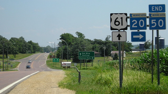
OLYMPUS DIGITAL CAMERAMN 50 doesn’t quite end at the same intersection as MN 20, but you can see it from there. The US 61 intersection is in the background.

On the south side of Red Wing, MN 292 parallels US 61/63 and serves a prison. Minnesota has little state routes serving state facilities all over the place.

I left US 63 behind for the time being at Lake City and continued down a very scenic US 61 to Winona. There’s no way this river-hugging road can be expanded to four lanes, although it needed it at times. The Mississippi River bridge at Wabasha was closed, leaving a gap for me in the bridges from St. Paul to St. Louis.
OLYMPUS DIGITAL CAMERA
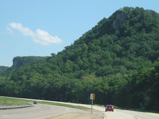
US 61 in southeastern Minnesota, south of Lake Pepin

At Winona I took the time to follow MN 43 through town and cross the river, then followed 43 the other way down to I-90. Winona to La Crosse will have to wait.
I got onto I-90, went west, and picked up US 63 again south of Rochester to follow all the way to Black Hawk County. Within that was one self-detour, going west on IA 9 to V18 since I had not been on that piece of road since the North Tama game at Riceville in 1996. Because of all the construction and traffic lights in Waterloo, I skipped that part of 63.

And that’s the end of my July vacation. I went to the Upper Peninsula for the first time, clinched I-35, 99% of US 63 in Wisconsin, added 34 counties in five states, and saw the north ends of five significant US routes.

Blog posts will resume Tuesday.

Posted in Trip Reports | Comments Off on Upper Midwest Trip Day 7
Oct 03

[stunned silence]

Texas 31, Iowa State 30.

Posted in Sports | Comments Off on [stunned silence]
Oct 03

Reflections on ski trips past

OLYMPUS DIGITAL CAMERA
My last visit to Mount Frontenac, until this trip. Note Y2K bug of sorts.

Frontenac, Minnesota, July 18 — So much about this feels wrong.

I am driving uphill on what used to be the switchbacks of the Easy Mile, at what used to be Mount Frontenac Golf & Ski. It’s 90 degrees outside, which my brain is having difficulty processing after having only been here before in the depths of winter.

OLYMPUS DIGITAL CAMERAThe seemingly unused but maybe not quite abandoned Frontenac ski chalet. Rental is to the left. This is the bottom of the Little Pepin slope.

This is where I learned to ski. It’s the only place I’ve ever skied. One Saturday every February for about six years, I would wake up when it was still dark outside to go up with my Boy Scout troop for an outing. I never got particularly good at it, usually sticking to the simple or medium-difficulty slopes. While I enjoyed it, I haven’t been skiing since.

And now, the only remnants of that era are the unused ski lodge and a lift chair beside a map of the ski slopes at what is now a golf course food stand.

OLYMPUS DIGITAL CAMERA
The incongruity of the palm tree and the ski map are par for the course for me here. The ski slopes closed in 2001.

The trips are part of my roadgeeking history — my first experience on US 63 north of Waterloo and first foray into Minnesota beyond the state line.

I am only here long enough to reflect and absorb the effects of the changes here on my memories. As I leave, a passing train makes the moment just a little longer. But after that, it’s time to re-enter my vacation mindset and leave Mount Frontenac behind. I have a gap on US 63 to close.

Posted in Trip Reports | Comments Off on Reflections on ski trips past
Oct 02

Upper Midwest Trip Day 6

Rochester, Minnesota, July 17 — What better way to spend a birthday than a day of roadtripping along a highway near to my heart, US 63?

Route: Business 2, US 2, WI 122 to river and back, US 2, WI 13, WI 137, US 2, US 63, WI 29, Route Y, US 63, WI 35, Route VV, US 63, MN 58, US 52 to S jct US 14 and turn around

OLYMPUS DIGITAL CAMERA

I took some morning pictures of the north end of US 51 (above), then went south into Hayward and east on Business 2, which is not signed in Wisconsin at all. I returned to US 2 and headed west.

WI 13 in Ashland had the roughest concrete on the whole trip, along with WI 137 to WI 112, where 137 became asphalt and was signed as Alt 2 (but no signs from 2 there).

At the Great Lakes Visitor Center, I watched a multimedia presentation and then wandered through exhibits. A big mural was just done in May, depicting scenes from the area’s history, and I suspect it features a lot of locals’ faces. Part of it is below.

OLYMPUS DIGITAL CAMERA

Then it was time for one of the major components of the trip: Driving US 63 south from the north end all the way to Iowa. The drive in northern Wisconsin gives the route an entirely different character than in Iowa, but that goes for most long routes.

Just before 63 meets 53 there’s a St Croix watershed visitors center, where I saw a 20-minute movie and looked at exhibits about the river.

At WI 46, there were signs for construction and fresh asphalt on the east-west segment. But turning south on 63, it was oiled gravel more or less. Could only go 35 mph and it was that way the whole way. But at least it wasn’t detoured, I thought.

I was going on pretty well, but then saw a 63 shield above “Detour ahead”. No bridge across river between east junction WI 29 and Route Y. Nooooooo!

OLYMPUS DIGITAL CAMERA
Black flagged on the last lap!

Then the same thing happened again right before the border. It looked like Route VV was asphalted and had new guardrails put in specifically for the detour. This was to build a bridge across the railroad. So there are about five miles of 63 in Wisconsin I missed, in two different places. BTW, the vast majority of paving in Wisconsin and the Upper Peninsula was asphalt, and much of it was very smooth. Can’t remember much if any concrete in Michigan actually. There are many benefits for pavement that doesn’t get caught in freeze-thaw cycles as often happens in Iowa.

Crossed bridge into Red Wing. Very scenic. Took pictures around the 61 junction, then decided to head straight for Rochester. GPS suggested MN 58, and I said why not. I was going to take that up instead of 63, but this worked better because 1) there was a lot of downhill going southwest-bound, and 2) the entire route was being resurfaced, and I was held up for 10 minutes at one stop.

OLYMPUS DIGITAL CAMERA
Red Wing, Minnesota, just south of the US 63 Mississippi River bridge

MN 58 ends at an interchange at US 52, which isn’t marked in the atlas. Heading south, 63 was NOT signed on 52, despite earlier news reports that it had been rerouted around Rochester. The six-lane 52 is progressing/looks nice, though.

New counties so far: 34 (4 NE, 2 SD, 14 MN, 5+4 WI, 5 MI)

Posted in Trip Reports | Comments Off on Upper Midwest Trip Day 6
Oct 01

Upper Midwest Trip Day 5

Hurley, Wisconsin, July 16 — If I had known I would spend 25 hours in Eastern Time I might have gone ahead and switched the cameras. (And then I found out I had set the wrong date on a camera anyway, because it doesn’t hold the date after the batteries are swapped out. Oops.)

Route: M-26 to end, US 41 to end, US 41, M-38, US 45, US 2

The Upper Peninsula is beautiful to drive through. Once. In July. It was very pretty, but I could only go about 40 mph because of all the curves. Strong thunderstorms had moved through before I started, but then it was sunny and I could see water evaporating from the road (and also on M-38 later).

I pulled up to the Copper Harbor Lighthouse tour about 10 minutes before the noon tour left. There was a handful of other people on the boat out to the lighthouse, and then we ran into a pair who canoed(!) out.

OLYMPUS DIGITAL CAMERA
Copper Harbor Lighthouse

After that, I drove up to north end of US 41, and so did a half-dozen other vehicles right after me. For a road whose paved part dead-ends it was a popular place. After a short stop at the visitors center, I started driving down 41, which like 26 was very winding and tree-y and didn’t open up until much later.

OLYMPUS DIGITAL CAMERA
About 2.5 miles south, Miami is still 1990 miles away. The accuracy of that number may be debatable because of assorted reroutes.

OLYMPUS DIGITAL CAMERA
First intersection for US 41 on the way to Florida. I’ve been on part of 41 in every state now.

In Calumet, I stopped at the Keweenaw National Historical Park museum but first I needed to eat; it was nearly 3 PM EDT. (While there is a place to eat in Copper Harbor, the use of Comic Sans on the sample menu disagreed with me.) I asked for some advice, got it, and walked to Joe’s Pizza, where I proceeded to order a pizza bread and “hot cheddar bites.” Hot, as in spicy. Ohhhh. *drinks gallon of water*

The museum is relatively new, lots of light colored wood in a building formerly the Masonic Temple. There was 14-minute documentary about mining in the area. After a strike in 1913, production began to wind down as the West became more profitable, and another strike in 1968 killed the rest. Calumet was a very multi-ethnic city, as many were at the time, but population plunged after mines closed. Downtown was brick paved in 1905. Number of churches cut in half. Very much a company town with company chipping in for churches, schools, library, fraternal groups (had a room on that too).

Left when the museum closed at 5 and still had <100 miles on the day. Of course, it was very light outside, what with this part of the UP being in Eastern Time for no good reason.

Followed 41 south, encountering a long delay for a long one-lane construction project at the Baraga County line. At Baraga I took M-38 east, where I had two separate short heavy downpours while the sun was visible, and saw two does along the way.

US 45’s trees are closer in than US 2’s are in places. I clinched 45 in Michigan by going to Land O’Lakes WI and turning around, which also gave me another Wisconsin county.

Got to Ironwood area about 8. Road is four lanes with turn lane west of M-28. I ended up at the Days Inn in Hurley, just into Wisconsin, at the north end of US 51.

New counties so far: 30 (4 NE, 2 SD, 14 MN, 4+1 WI, 3+2 MI)

Posted in Trip Reports | Comments Off on Upper Midwest Trip Day 5
Sep 30

Upper Midwest Trip Day 4

Hancock, Michigan, July 15 — Here’s the thing about Duluth: Its maps need a Z-axis. From I-35 near the riverfront, as you go inland, the streets go up at a 45-degree angle. It’s San Francisco with eight months of winter. I was glad I was there in July and not January.

I spent the morning and early afternoon at the Depot museum and then a train ride along the North Shore. The train had different cars from different eras. I recommend it for anyone interested in railroad history. All my driving for the day was done after 2.

OLYMPUS DIGITAL CAMERA
Trains at the Lake Superior Railroad Museum

OLYMPUS DIGITAL CAMERA
The seat backs on this car can be flipped back and forth.

Route: I-35, US 2, MI 28, MI 64, US 45, MI 26 (clinched US 2 in WI)

US 2 has smooth asphalt and plenty of passing lanes. Trees are plentiful throughout. It took three hours to go all the way across Wisconsin on US 2, including a prolonged photo stop at US 63’s north end. (More on that later.)

Got to the Michigan welcome center right across the river at 4:55, only to find out the hours were 8-4. Wisconsin’s welcome center is still bathrooms only, which in some respects isn’t that welcoming at all. This governmental misstep should be rectified.

Construction on bridges on MI 64 was controlled by stoplight.
Despite a reroute of M-64, US 45 still ends in Ontonagon. One block before the sign, there’s “To South 45” with right arrow, and then another, and another. East a block, north two blocks, then south, and voila, you’re heading south on 45.

OLYMPUS DIGITAL CAMERA

My drive was bathed in golden sunshine surrounded by trees. Perhaps overdoing it on the trees for me, but otherwise perfect drive. I got a room at the Hancock Ramada, right by the bridge into the Keweenaw Peninsula.

Google is in on the theory that the Upper Peninsula is really Occupied Wisconsin — despite my being in copper country and the Eastern Time Zone, Google Maps focused on the Badger State when I loaded the page.

New counties so far: 27 (4 NE, 2 SD, 14 MN, 1+3 WI, 3 MI)

Posted in Trip Reports | Comments Off on Upper Midwest Trip Day 4
Sep 29

Upper Midwest Trip Day 3

Duluth, Minnesota, July 14 — A year and a half after visiting the south end of I-35 in Laredo, I made it to the other end, clinching its entire mainline length in the United States. I also made it to Lake Superior, my last Great Lake.

Route: US 169, to MN 13, I-35W, I-35E, MN 36, I-35W, I-94 (to x245 and turn around), US 61, MN 36, I-35E, I-35 (with jump-off to MN 70), I-535, US 53, US 2, Hammond Ave, I-535, I-35, MN 61, CSAH 61, MN 61 to CSAH 3 and turn around, MN 61, I-35

The day was mostly overcast, with a couple small showers, the only rain I’d have the whole trip.

I drove up I-35E, but also went over to Minneapolis to see TCF Bank Stadium and drive on the new I-35W bridge.

OLYMPUS DIGITAL CAMERACarved into TCF Bank Stadium are the names of all Minnesota’s counties. Also around the stadium are large informative markers about various tribes in the state.

Good concrete on I-35E north and then on much of I-35 itself. There was construction going on south of Duluth.

My Minnesota Atlas and Gazetteer showed MN 361 running along old US 61 at Pine City, but Google Street View showed it had been turned over north of MN 70. Since then, though, the entire route has been decommissioned, and the county  put up “Old 61” markers. I went west on MN 70 for two counties just off the interstate.

OLYMPUS DIGITAL CAMERA
To be historically accurate, the cutout should say “Minnesota” instead of “Hwy” across the top, and perhaps use blocky numbers. But a big compliment for marking the route.

I-35’s northernmost rest area, in Duluth, is a joint one off the interstate with a scenic view.

WI 35 was closed between US 2 and I-535, thwarting my plans for a full loop in Superior. However, I did get pictures of the route, which was down to one lane across the bridge.

OLYMPUS DIGITAL CAMERA
With about 30 seconds of traveling, I clinched Wisconsin’s interstates. The light ahead marks the end of I-535.

Continuing north, I clinched I-35 in Minnesota and unsuffixed I-35 in the entire country, missing only I-35E through Dallas. I kept on going, on MN 61, seeing a lot of vehicles heading south with canoes. I followed the scenic route, likely the oldest 61, northward and followed MN 61 up until CSAH 3 north of Two Harbors. Cook County was just too far away.

It was lighter this time when I got back to Duluth so I took I-535 down again, with a double loop back.

I drove back north to downtown, then on Lake Street into a long spit of land on Minnesota Avenue. Went to very end, down to the beach, and touched the water of Lake Superior.

OLYMPUS DIGITAL CAMERA
Neither Two Harbors nor Thunder Bay is used as a control city at the end of I-35, just the “North Shore” of Lake Superior. Beside the van are signs that say “End 35 1/4 mile” and “Signal Ahead 1/4 Mile”.

New counties so far: 21 (4 NE, 2 SD, 8+6 MN, 1 WI)

Posted in Trip Reports | Comments Off on Upper Midwest Trip Day 3
Sep 28

Upper Midwest Trip Day 2

Chaska, Minnesota, July 13 — Since I was starting the day in Vermillion, I decided that I would forgo anything west. This turned out to be good because US 18 was closed between SD 19 and I-29. Then, when I elected to do I-90 to cross into Minnesota instead of SD 11, I got another break because MN 23 was closed between I-90 and Pipestone.

Route: SD 19, (SD 19A to Centerville), SD 46, I-29, US 18, K12, A18, SD 11, 57th St, Sycamore, SD 42, I-229, I-90, US 75, MN 23, MN 7, MN 22, US 212, MN 41

OLYMPUS DIGITAL CAMERA
SD 19A, which runs through Centerville, is one of the few suffixed routes left in South Dakota. The wide shield makes the state outline truer to form.

Aerial photos showed there are two truss bridges across the Big Sioux River, near US 18 and A26. Both were closed, the one near US 18 more recently so.

At Pipestone National Monument I watched the film and walked around the grounds. It was interesting; some dioramas at park HQ looked original to the time it was built (late ’50s/early ’60s) but remained informative.

OLYMPUS DIGITAL CAMERAPipestone National Monument

MN 23 had “Road Work Next 30 Miles” at the north Pipestone junction. Fortunately it wasn’t that bad, the blacktop-style followed by new, good concrete much later on. It had a couple of random four-lane segments and some one-lane-divided at intersections.

I was making good time, so I headed east on MN 7 to see how close I could get to the Twin Cities. Turns out, the whole way.

New counties so far: 14 (4 NE, 1+1 SD, 8 MN)

Posted in Trip Reports | Comments Off on Upper Midwest Trip Day 2