Jan 24

Dubuque transfer has a catch


September 2, 2008: North end of IA 32 in Sageville.

The Iowa Transportation Commission approved the transfer of jurisdiction of all of IA 32 and the part of US 52/IA 3 inside the city of Dubuque at its meeting in Ames last week. I asked the DOT back in October — when the transfer was inadvertently included and then removed from the agenda — if anything was going to change before the Southwest Arterial opened. I was told at the time that there would not be any change in signs until that happened, which won’t be until 2019 or 2020. In addition, Iowa will have to apply to the AASHTO Special Committee on US Route Numbering to reroute US 52 along IA 136 and US 20 and the not-yet-built arterial.

So, unless and until signs are down in the field, IA 32 is a “dead highway walking” but is not a decommissioned route.

Posted in Highway Miscellaneous | Comments Off on Dubuque transfer has a catch
Jan 23

RealClearPolitics analysis of Midwest presidential vote

Maps, stats, and charts abound in the RealClearPolitics study of how Donald Trump nearly swept the Midwest in 2016. Iowa is one of the states selected for extra study, and was picked out again in the conclusion to the RCP regional series.

Posted in Iowa Miscellaneous, Maps | Comments Off on RealClearPolitics analysis of Midwest presidential vote
Jan 20

The flags on “Designated Survivor”

As I’ve mentioned before, I’m trying to hold interest in “Designated Survivor” but there are plot elements rubbing me the wrong way. The “winter finale”, which included a woman walking away from a serious car crash and being well enough to run/drive/shoot a gun not long thereafter was clearly “24”-esque, and I accepted the nature of that show’s universe, but it didn’t work for me here.

While trying to be grounded in reality, the show keeps taking shortcuts and, for a political thriller, appeared to be completely lost on how vacancies in the two houses of Congress are filled.

Then I saw the flags. Not the ones the audience is waving, or the ones that feel like overcompensation because the show is filmed in Canada, but the ones on the partially ruined Capitol.

designatedsurvivorflags

This is a screen capture from the last episode, when the vice president is to be sworn in. The set designers/CGI artists obviously modeled the whole thing after Barack Obama’s inauguration. But two of those flags have meaning. The second and fourth flags represent the president’s home state. Those flags have 21 stars, representing Illinois. We were given no indication of where Bauer’s character is from — although it’s likely New York (the Cornell sweatshirt), Maryland, or Virginia (being a Cabinet secretary) — and all of those would get a 13-star flag. But this ceremony isn’t for the president, it’s for the vice president, and it’s been made clear he is from Oregon. (And that’s another thing — a character with MacLeish’s background can only be from one district in that state, and it’s not any of those near Portland.)

It’s just a teeny tiny thing, I know. But man, it’s attention to detail that makes things work and allows viewers to accept the universe of the show. For all the detail paid to making a replica of the Oval Office (in the link above), this seems like something someone should have caught.

(This counts as my inauguration-related post.)

Posted in Uncategorized | Comments Off on The flags on “Designated Survivor”
Jan 19

A long wait for Pleasantville


October 8, 2004: Northbound former IA 181 at the junction of IA 5 and 92 south of Pleasantville, a year after the Pleasantville bypass opened and IA 5 was upgraded completely to four lanes between I-35 and Knoxville.

The Knoxville Journal-Express had a “from the archives” bit for Jan. 13, and it mentioned a meeting about the Pleasantville bypass 25 years ago — in 1992. The highway wouldn’t be upgraded for another 11 years beyond that, with the bypass finally opening in fall 2003. The “community was concerned,” the recap mentions, but it’s hard telling whether it was that or plain old bureaucracy that caused the delay.

Posted in Highway Miscellaneous | Comments Off on A long wait for Pleasantville
Jan 18

CAL losing junior high, high school

The Coulter-Alexander-Latimer school district, hammered by the population decline affecting nearly all of rural Iowa and the end of a sharing agreement with Dows a decade ago, is unable to hold on to its independence.

CAL will send grades 7-12 to Hampton-Dumont in fall 2018, the Mason City Globe-Gazette reports. That means there will be a full year and a half of “lasts” ahead — except the last football homecoming, because CAL already couldn’t field a football team and made an agreement with Clarion-Goldfield-Dows for 2016-17.

If not for the significant part of H-D in Butler County (Dumont and Aredale), “Central Franklin” would be a good school name, but since this is a one-way sharing agreement the current status of H-D is unlikely to change.

Posted in Schools | Comments Off on CAL losing junior high, high school
Jan 17

One contractor, two sign color problems


July 2, 2014: City limit sign for Hudson just north of IA 58’s rebuilt south end. Black-on-white and all-caps are both non-standard.

When IA 86 opened from IA 9 to the Minnesota border in November 2013, the “Dickinson County” sign was not only the old small style, but it was black text over a white background. It was fixed in a month.

When the reconstructed US 63 opened from the south side of Hudson to US 20 in summer 2013, more signs were the wrong color. The one seen above is still there.

As it turns out, both the IA 86 project and US 63 project had Cedar Valley Corp. as the primary contractor. If the contractor was in charge of the signs (and the letting contract for 63 did have signage pages), that could explain why two distant locations had identical issues.

Posted in Highway Miscellaneous | Comments Off on One contractor, two sign color problems
Jan 16

How do you ‘rebrand’ a corner?

The federal government gave the final approval last week to redo the I-35/80 interchange with IA 141 and add ramps at Meredith Drive, the Des Moines Register reports. Here’s the nugget that makes it weird:

The interchange is located at the junction of Urbandale, Johnston and Grimes. It’s known locally as Rider Corner for the 90 degree turn the interstate makes and for the Rider Coal Mine that once operated nearby. Johnson said re-branding will be a part of the project.

Why does the corner need to be “rebranded”? Is it because there was nothing out there until 25 years ago, or because a suburb can’t be associated with something as unfashionable as a coal mine? The name is on old USGS topo maps, so it’s not necessarily gone from memory. Is the city of Urbandale going to sell naming rights (“Rider Corner Presented by SuperTarget”)?

Posted in Construction | Comments Off on How do you ‘rebrand’ a corner?
Jan 13

Pilot Knob is not Iowa’s second-highest point. Or the third.


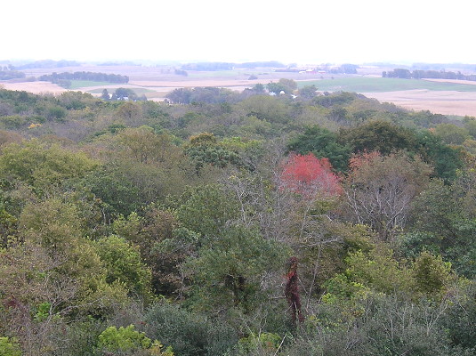
October 4, 2016: The view from the Pilot Knob observation tower, which is 30 feet tall. Enjoy it before I drop some earth-leveling news.

While working on the page for IA 237, the old spur to Ocheyedan, I had a realization. For decades, Ocheyedan Mound (elevation 1613 feet) was considered the highest point in Iowa. But when that recognition was moved to Hawkeye Point (el. 1670), it’s not like the mound disappeared.

Then, last fall, after I visited Klemme and toured the Winnebago factory complex in Forest City, I stopped by Pilot Knob State Park, which will be 95 years old in 2018. Like Ocheyedan Mound, the highest point in the park is a glacial kame. But unlike the mound, it has a specific claim.

OLYMPUS DIGITAL CAMERA
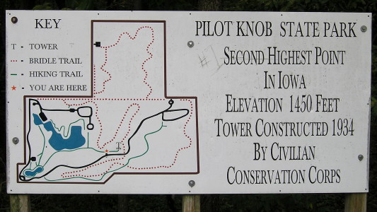
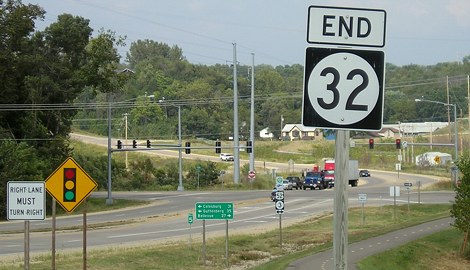
October 4, 2016: Number 2 on the sign, but Number 1 in someone’s heart.

Wait a minute. Wait. Aaaaaaa. Min-ute.

pilotknobtopo 
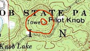
USGS topo; 1400, 1450 marked

OLYMPUS DIGITAL CAMERA
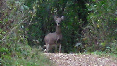
October 4, 2016: On the path to the CCC tower at Pilot Knob: Doe, a deer, a female deer.

An elevation of 1450 is a drop of more than 100 feet from the two Osceola County points. Once the highest something becomes the second-highest something, it follows that the second-highest something should become the third-highest something. But even the official Iowa DNR page still bills Pilot Knob as the second-highest point in Iowa, and that can’t be remotely true.
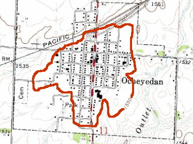
ocheyedan1550 USGS topo

The entire town of Ocheyedan is above 1550 feet — 100 feet higher than Pilot Knob. A significant percentage of Osceola County is above 1500 feet.

It doesn’t take much of a peak or rise to be a high point — at Hawkeye Point, you wouldn’t think about it if not for the newish stone slab saying so. But if you were standing in the parking lot of the now-demolished Ocheyedan school, you would be at a higher elevation than even the top of the Pilot Knob observation tower.

The reassignment of Iowa’s highest point automatically should have demoted Pilot Knob in the hierarchy, and the maps above show that it should go even lower. With the information and measuring tools we now have available, why hasn’t anyone else noticed this?

Posted in Geography, Iowa Miscellaneous | Comments Off on Pilot Knob is not Iowa’s second-highest point. Or the third.
Jan 12

Council Bluffs remakes Broadway intersection

OLYMPUS DIGITAL CAMERA
June 22, 2013: East Broadway in downtown Council Bluffs. The owner of the Mississippi State flag isn’t lost, just here for the College World Series. This photo is west of the Broadway/Kanesville intersection on the historic Lincoln Highway.

Although (as of this writing, after a call to the city) US 6 is still signed through Council Bluffs on West Broadway and Kanesville Boulevard despite an approved transfer of jurisdiction, the city is already changing the road. The Nonpareil reported last week that in a project that ended Dec. 29, the intersection of East Broadway and Kanesville was reconfigured from a Y to a T. The intersection was built in the early 1980s, when Kanesville was extended westward so US 6 could bypass downtown Council Bluffs. The Lincoln Highway gets back onto 6 here, goes northeast to the next intersection, then heads north on North Broadway. The road pattern that existed in the area when the Lincoln Highway went through and US 32/6 exited the city on McPherson is nearly buried, and this changes it further. The intersection is where IA 183 ended from 1969 to 1981 (after taking over the US 30A designation south of Missouri Valley) and a sign still pointed to the route until 2003.

The unusual part of this is that last I knew, the Iowa DOT was going to keep control of this part of Kanesville, since it’s east of downtown. Based on a photo of the new intersection, though, only a tiny portion of that road needed work, so there was probably some sort of agreement made.

Posted in Construction | Comments Off on Council Bluffs remakes Broadway intersection
Jan 11

G is for Gladbrook

IF

IF
July 7, 2015: The former Gladbrook-Reinbeck Middle School was the Gladbrook High School before 1988.

The Gladbrook school is another recent addition to the list of closed schools in Iowa. This closure in 2015 triggered something that had never happened in Iowa history: Residents petitioned for the district’s dissolution. The yearlong process reached the point of a draft map being released to disperse the district among five bordering ones. But on Aug. 23, the board rejected the petition over the validity of signatures, making the previous year of meetings and efforts all for naught.

The GR school district and the city spent nearly $550,000 on a fitness center attached to the school that opened in 2008. There’s also an indoor pool, but the pool’s Twitter account has all of eight tweets in 50 days in 2014.

Posted in Schools, Sequences, Tama County | Comments Off on G is for Gladbrook