Jul 11

Matt Campbell is Tim Cook

The nicest response I can think of to Iowa State’s new outfits is “furious.” Matt Campbell’s disgust for the color gold (never worn as anything other than an accent in 2017) has reached its logical end with three solid-color options of white, red…and black.

IOWA STATE SHOULD NEVER EVER EVER EVER WEAR BLACK UNIFORMS. EVER.

Campbell has been talking about this for a while. If Nike’s behind the total purge of stripes and accents, why not just contract it out to the College of Design? Students there might actually know what our colors are and mix them accordingly.

Iowa State fans know about all-whites for two main reasons: The Texas Stormtroopers and Nebraska’s surrender uniforms. The assignment of the 2018 Texas football game to the Longhorn Network without a CyTV simulcast says which is the Empire and which should pray the deal isn’t altered further, don’t you think?

The Campbell era, in a way, reminds me of Tim Cook’s time at Apple. Cook put Jony Ive in charge of the user interface, bleeding it dry and eliminating important visual cues. Cook’s Apple has done everything it can to alienate Mac users to the point of making products with an inferior collection of ports and hardware that doesn’t work. (I think around 2012 he bumped into the wrong person who cursed him with, “Thinner.”)

But he’s making Apple a trillion-dollar company! But the Facetweetgramming youths are where it’s at!

But he beat Oklahoma! But he gets the ‘kroots, who are all about the Facetweetgramming! #HashtagsAreBrewing

To which…*deep sigh* Yeah. Winning works and gives you a lot of leeway. I clearly am not the target audience, for either Campbell or Cook. Those of us who want to hold close to certain things because of loyalty or have-you-seen-the-competition while being increasingly frustrated at the trendlines aren’t able to do anything but rant on the Internet about it.

Posted in Sports | Comments Off on Matt Campbell is Tim Cook
Jul 10

The last outs for CAL

CALGymScreencap
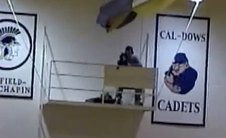
February 19, 2001: A screencap of a video pan across the wall of CAL’s gym in Latimer. The teams depicted were Dows-CAL (the junior high when CAL and Dows were sharing, keeping Dows’ nickname of the Tigers alive), Sheffield-Chapin (sharing with Meservey-Thornton for a decade before that, showing the board’s age), CAL, Southeast Webster (started sharing with Prairie Valley in 2014), and Ventura (started sharing with Garner-Hayfield in 2012, consolidated 2015).

The Coulter-Alexander-Latimer Cadets have played their last regular-season games in any sport. The baseball team lost 15-5 to North Tama on Thursday and lost 5-1 to Roland-Story on Friday. This is the second time in four years that North Tama was the final conference sports opponent of a district that surrendered its high school (Northeast Hamilton, 2015). CAL’s final home game, played in Alexander, was a 5-3 win over Janesville.

CAL was the last high school standing of the last six members of the North Star Conference, which disbanded in 2006. CAL will not have a high school next year, entering a whole-grade sharing agreement with Hampton-Dumont. The district will be named HD-CAL, but for the moment there will be no changes to buildings or uniforms.

CAL’s district baseball game tonight is against Northwood-Kensett. The winner gets the right to have their clock cleaned by Mason City Newman.

UPDATE: Northwood-Kensett 15, CAL 0 (4 innings).

Posted in Sports | Comments Off on The last outs for CAL
Jul 09

Keokuk’s different climate zones

The USDA’s Plant Hardiness Zone map “is the standard by which gardeners and growers can determine which plants are most likely to thrive at a location,” the website explains. Three sub-zones — 4B, 5A, and 5B — cover Iowa except for a narrow band at the southernmost point.

hardinesskeokuk

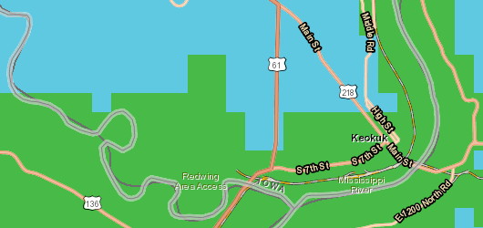
The blue is Zone 5B; the green is Zone 6A. At this rendering level, the 6A line creeps up the Mississippi River to Galland School but doesn’t extend beyond the shoreline. On land, the green zone runs a mile and a half to two miles into Iowa, including part but not all of Keokuk. The east part appears to run near the survey line between sections 22-23-24 and 27-26-25 in T65N. Since most of the Keokuk city grid is angled, there’s no numbered street running the length of the line, but the short Cleveland Avenue is there.

The entire run of US 136 in Iowa lies inside this growing zone. It’s still not a place to put palm trees, though.

Posted in Maps | Comments Off on Keokuk’s different climate zones
Jul 06

Mall between two school districts

A not-particularly-trumpeted but governmentally significant thing happened July 1: The tax increment financing district for Coral Ridge Mall expired. The mall opened 20 years ago at the end of this month. The city of Coralville’s website explains:

At that time, taxes on the base property value as well as increased property value will be available to all taxing bodies in Johnson County. The release of value and TIF revenues in the Mall TIF District are estimated to be $364.8 million in taxable value and $10.7 million annually in revenues to local governments.

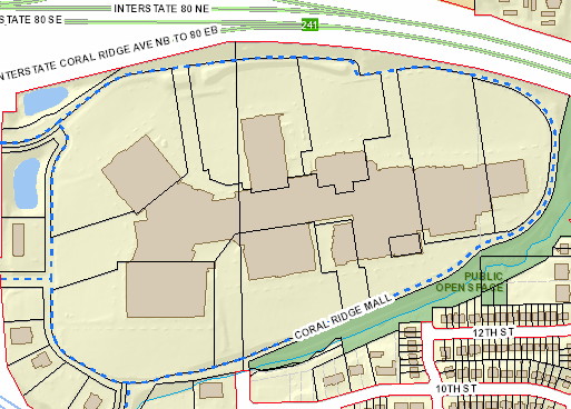
In either a geographical quirk or sign of strategic planning, those taxing bodies include not one but two school districts: Iowa City and Clear Creek Amana. In the below parcel map, from the Johnson County Assessor’s Office, the vertical black line that runs the length of the property divides the districts.

MallJoCoAssessor

The line used to be 25th Avenue (you can see a smidge of it in white at bottom center) but now runs right through the (Ann Taylor) Loft store. The now-subdivided former Sears and Dillard’s are on the CCA side; the movie theater, J.C. Penney, Target, Best Buy, and soon-to-close Younkers are on the Iowa City side.

CCA and Iowa City, as two of the handful of districts in Iowa on a long-term enrollment winning streak, need the un-TIF’ed money either the most or least among districts in the state.

Posted in Geography, Schools | Comments Off on Mall between two school districts
Jul 05

Dubuque highway chronology, heavily revised and corrected

Sometimes better information throws your settled pattern for a loop.

Part of what I have stated on this website for IA 3’s history in Dubuque is wrong. The maps never would have distinguished the difference, but the online route description, made available in 2016, does. The state highway never ended at US 61/151 before the present-day expressway/freeway was built, according to the route description; its end was officially US 20 from at least 1948 until 1991.

But … that’s a direct contradiction of the primary road sufficiency logs, which I used as the basis for my IA 3 history. How do I solve this? Well, I can’t, unless someone in Dubuque happens to have 20th-century photos of the relevant intersections. I can, however, note the discrepancies.

It makes a mess of some maps I had though. The bright side is, with the route descriptions for US 20, 52, 61, and 151, plus some sleuthing in what’s available online for the Dubuque Telegraph Herald, I believe I have been able to reconstruct an accurate history of the highways in Dubuque with just a couple of ambiguities.

The Dubuque Highway Chronology is different from others I’ve done because the map covers a relatively small area, downtown. The rest of changes in the metro are mentioned but I felt any bigger size took away from where the important stuff was happening — especially since so many maps are needed.

The corrections come right up to the present day. I didn’t think that the conversion of certain streets in downtown Dubuque to two-ways in 2014 affected US 52/IA 3, given the exit configuration on US 61/151, but I was wrong on that too (and really should have fixed it earlier since I did get a PowerPoint from the DOT about it). It’s actually kind of funny because it’s resulted in a transfer of jurisdiction of one lane but not the other of a city street (11th). The east end of IA 3 is where it has been, on 9th Street, but the west beginning technically is 9th now too.

Now, with all the changes, I was afraid I wasn’t going to have good pictures of points I needed. I still kind of don’t BUT I was able to pull from 2007, 2013, 2015, and 2016 to augment not just IA 3 but US 20.

Posted in Maps | Comments Off on Dubuque highway chronology, heavily revised and corrected
Jul 03

In defense of rest areas


June 5, 2014: Various methods of getting places are shown at the I-35 southbound Story City rest area. Inside is a historic look at the highways of Story County — the Lincoln Highway, US 30, and I-35.

Rest areas are an integral part of the interstate highway system. They’ve been around since the beginning. But now, as many of the facilities in Iowa reach the end of their lifespans, the Iowa DOT is looking to eliminate some of them.

While long-haul truck drivers get safe parking at a rest area, for the typical driver, rest areas’ primary purpose is much more earthly — answering the call of nature. And after some time departed from home or a meal, with a fresh 32 ounces of pop involved, that call can be rather insistent. There’s a reason I referred to new US 20 in western Iowa as a “bladder buster” that has been alleviated only partially with a gas station at the IA 4 exit. Because Iowa doesn’t do true rest areas on non-interstates, it’s the best we’ll get.

With a rest area it’s easy: Take the short ramp, take a space, cross one door. Without, we’re talking about longer ramps, potential left turns, parking awkwardly at the front or side of a gas station, looking for directions to the middle or back of the building…and maybe finding a single-sex single-use facility already occupied*. Get in a more urban space and throw in stoplights, necessity of selecting a target, and maybe even more turns. And keep in mind I’m speaking as a solo driver, and not someone with one or more children in the back who really should have gone before we left.

And all of that is only if there’s something at the next exit. Unlike more-populated states, exits in Iowa without a town nearby rarely have a gas station, and almost never have more than one. It’s not quite as true as it was a decade ago, thanks to aggressive campaigns from Kum & Go/Pilot/Flying J/Love’s, but even so, I think the bulk of such cases are on I-80 between Iowa City and Davenport. I say gas station specifically because I can name the two interstate fast-food exceptions: The Burger King in the Middle of Nowhere (Northwood Welcome Center) and the Wendy’s in the Middle of Nowhere (I-29/IA 2 Welcome Center).

Around the turn of the century, the DOT began a slow redesign of Iowa’s rest areas to make each stop unique and reflective of the region’s history. It’s another function rest areas are well poised to serve. Here’s a report from 2003 showing the first changed ones. But two of the rest areas that have been praised for their design and educational components — the southbound I-29 welcome center at Sergeant Bluff and the southbound I-35 rest area at Story City — are on the proposed closure list. The I-29 rest area, with a Lewis and Clark theme, opened March 1, 2000; the I-35 rest area, celebrating Iowa transportation history, opened in 2009. Their lifespans would be wastefully cut short.

I can see the DOT closing the strictly parking-only areas. Those are freight-specific, for the most part, save for the scenic overlook near Story City (which, for all those who complain about I-35 in north-central Iowa, is a nice counterpoint). Adding semi parking spaces somewhere else could offset. But if you’re driving between Des Moines and Sioux City, and both the I-29 Missouri Valley and I-680 Loveland rest areas go away, between Adair and Onawa your options drop to a few gas stations, the Loveland overlook (WB only), and Missouri Valley McDonald’s. The I-680 rest areas rank at the bottom in usage because that is the least-traveled interstate in Iowa.

The one place where I’d say there was a misjudgment of location in the original rest area plan is the pair on I-80 at Davenport. The eastbound one is too close to the Illinois Welcome Center; the westbound one isn’t a welcome center; neither can serve I-74 or I-280 traffic. The best place would have been just west of I-280 … which happens to be where the World’s Largest Truckstop took root.

Rest areas are good places to check the weather and use the phone/Wi-Fi to make calls/look something up without doing so at 70 mph. (Plus, there are those hotel-coupon books, which can be surprisingly useful.) There’s also something to be said for the rest areas on the periphery of urban areas. They allow a driver who doesn’t want anything other than a pit stop a chance to get off and on easily without the rigamarole described above.

Nationally, between state budget cuts and commercialization advocates, rest areas are caught in a tug of war. Wisconsin kept its rest areas but shut down welcome center functions in 2009, leaving sad empty spaces at the US 61 and I-94 southern entrances to the state among others. A year ago, reporter Haley Byrd did a deep dive into a movement not to remove freeway rest stops but allow them to be turned into service plazas like on toll roads, which would go against an original rationale of the entire system.

Rest areas are designed to do a few things really well. To reduce their availability would, in my opinion, not serve the interest of a public highway system.

*Logistically, I think single-spot facilities/those without dividers could be converted to universal restrooms, but practically, there’s the risk of barging in on some poor sap who didn’t lock the door.
Posted in Highway Miscellaneous | Comments Off on In defense of rest areas
Jul 02

Even with grant, historic bridge replacement too expensive

A closed connection in Iowa’s Great River Road looks like it will remain that way, and perhaps permanently.

The Iowa DOT offered $1.5 million to the city of Burlington to go to repairs of the Cascade Bridge, but the city rejected it because replacement of the bridge will cost between five and six times that amount, the Hawk Eye reports. The city can’t afford that until 2024, while the DOT grant would require spending by 2021.

I mentioned the bridge closure in a 2015 blog post after encountering it personally while trying to follow the GRR. The other closure I mentioned, X28 near Montrose, has been repaired.

Posted in Construction | Comments Off on Even with grant, historic bridge replacement too expensive
Jun 30

Country music has an alcohol problem

Finally, someone else noticed.

The beginning of the bro-country era can be pegged to mid-December 2012, when Florida Georgia Line displaced Taylor Swift at #1 on the Billboard Hot Country charts, stayed there for five of the next six weeks, and then crushed everything from mid-April to Labor Day 2013. There were songs earlier in 2012 that were harbingers — notice that there were #1s called “Drink in My Hand”, “Drink on It” and “Drunk on You” — but the sheer dominance of BABY YOU A SONG signaled change had come, and not for the better. (It gets worse; FGL has had the current Hot Country #1 for seven months.)

Were there allusions to drinking before? Sure. But the singers didn’t build their style and empire around it. That was, until Kenny Chesney decided he didn’t want to leave the beach, and opened the door for groups focused on drinking and trucks and women and drinking in trucks with women.

The headline on this 2015 story sums it up: “Bro-Country Is a Plague, and Florida Georgia Line Is Patient Zero.”

Posted in Uncategorized | Comments Off on Country music has an alcohol problem
Jun 29

Dinsdales, Stoakes in track hall of fame

The stars of North Tama’s girls’ track championship four-peat were inducted into the Iowa Association of Track Coaches Hall of Fame earlier this month. Story: Traer Star-Clipper.

Brooke and Blaire Dinsdale led the way in 2006-08, and Stoakes followed with a one-woman Class 1A championship. Also pictured in the story: The last time girls’ state championship trophies looked good.

Here’s the Waterloo Courier story covering the Dinsdales’ first track championship, in 2006. The Dinsdales were inducted into the IGHSAU Track Hall of Fame in 2013.

Posted in Tama County | Comments Off on Dinsdales, Stoakes in track hall of fame
Jun 28

Webster County hip to Historic Highway 20


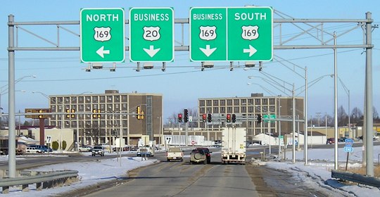
December 12, 2005: Business 20 approaches US 169 on the west side of Fort Dodge. Ahead is the beginning for Business 169 (former IA 926) as well.

The Historic U.S. Route 20 Association, whose work I have promoted on this blog in the past, is making great strides in Iowa for getting old Highway 20 signed across Iowa. While the idea is to mark it as it was signed in 1926, sometimes it will be what got paved in the 1930s.

Webster County would be among the latter, to keep the mainline on paved roads; the diagonal from Fort Dodge to Moorland cleared out stairsteps in 1930. The segment inside Fort Dodge likely will follow “old 20” as it was from 1937 to 1987, as shown on my Fort Dodge Highway Chronology.

Earlier this month the Webster County Board of Supervisors, following the Fort Dodge City Council, approved participation in signing Historic 20 across Iowa, the Fort Dodge Messenger reported.

Posted in Highway Miscellaneous | Comments Off on Webster County hip to Historic Highway 20