
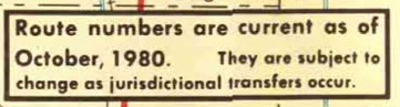
The disclaimer on the 1981 Iowa highway map.
From the start, I have limited the reach of Iowa Highway Ends to those state highways on the 1981 map and later. (For the US routes, since there are far fewer, any once-existing state line is fair game.) I set that because the Great Decommissioning of 1980 was a watershed in both the scope and purpose of the Iowa highway system. Also, finding the precise in-town endpoint of a highway that hasn’t been signed for decades can be difficult because it could change over the years. Spurs would have a few blocks added or subtracted in an effort to be more consistent in where in the business district they ended, or in relation to a construction project.
There are multiple dates involved in the creation or turnover of a highway, and there can be months in between:
- The day(s) the local jurisdiction (city/county) accepts.
- The day the Highway Commission approves (or, when the system was expanding, the day of the meeting the number was designated).
- The day the signs go down or are put up, or the road opens.
Unless Jason or I have been able to track down that last date, we’ll typically use the second for historic routes, first based on my days spent going through microfilm Highway Commission minutes to get the starting dates for many routes and now on a read-through of the legal descriptions to get the ending dates. A substantial majority of those routes affected in 1980 had both jurisdictional transfers and signs down in July. Otherwise, if I can find it, the date a road opened or closed gets top billing. (Until a year ago, getting that for the 20th century relied on hours of scrolling through newspaper microfilm or my visits to the DOT library in 2006.)
With the online information, and notes from the 1980-81 route logs that I made in 2010, the breakdown of the last spur highways involved in the Great Decommissioning looks like this:
- On the 1981 map, but not in the 1981 route log: 42*, 95**, 155, 166, 213, 219, 226, 231, 246, 328*, 365. Then there’s IA 154, which we know was replaced by IA 187 in November 1980.
- On the 1981 map, but already turned over inside city limits: 125, 237, 351, 352, 356. Also the part of IA 114 in Wellman, which still ran south to IA 92 until February. For these routes, I have added the city limits as a “temporary” end, no photo necessary.
- Turned over in their entirety in 1981: 216, 303, 326, 390
- Not on the 1981 map, but not turned over until April: 90
That makes 23 highways that, in some fashion, existed on October 10, 1980, but not January 1, 1982***. To simplify that in the index, I lumped all but IA 95** into a “Late 1980 or 1981” category on the index. Any route that had an endpoint changed in 1980 or 1981, but was/is still around, is treated normally.
Coincidentally, that leaves 23 spur routes that were dropped over the next 20 years — until the Second Great Decommissioning. If I had based my website on the 1983 map instead, the spur index would be 17% smaller.
While making all those changes, I also altered the color for the “Late 1980 or 1981” numbers in the table. Finally, IA 216 had been omitted from the index at some point; it’s in now. Those responsible have been sacked and replaced with 40 specially trained Ecuadorean llamas.